🚦 Ohio Go System
ZIP Code
45385
Radius
20.0 mi
Cameras
45
Incidents
1
Construction
25
📅 Last Updated: 2026-01-25 18:16:13
🌡️ Nearest Weather Sensors
D08 OH184MS GRE IR675 0 78 IR 675 North of Feedwire Rd
📍 8.8 miles away
Temperature
20.6°F
Visibility
1.2 mi
Road Temp
19.7°F
D08 OH063FS GRE IR675 07.50- IR675 @ MOT County line
📍 9.4 miles away
Temperature
14.7°F
Visibility
-1.0 mi
D07 OH045FS CLA IR70 44.30- IR70 @ IR675
📍 12.8 miles away
Temperature
14.9°F
Visibility
-1.0 mi
🌤️ Current Conditions Overview
Weather
Snow
Visibility
Poor
Traffic Flow
Light
Cameras Analyzed
45
⚠️ Active Hazards & Events
- I-70 at I-675: Vehicle incident
- I-75 at South of Dryden Rd: Vehicle incident
- I-75 at Main St/SR-48: Vehicle incident
- I-675 at Indian Ripple Rd: Vehicle incident
- I-75 at SR-4: Vehicle incident
- I-75 at SR-725/Miamisburg Centerville Rd: Vehicle incident
- I-71 at SR-73: Vehicle incident
- I-75 at Dixie Highway: Vehicle incident
- I-75 at Stanley Ave: Vehicle incident
- US-35 at SR-835 / Research Blvd: Vehicle incident
🚨 Active Incidents (1)
I-75 Northbound.
The left lane is blocked on I-75 North beyond SR-4/Keowee St, due to.
🚧 Construction Zones (25)
GRE-35-5.63 eastbound.
Construction of an interchange at the routes’ intersection between Xenia and Beavercreek. Traffic is
Distance: 3.5 miles
Wagner-Ford Road to I-75 Southbound .
The Ramp from Wagner-Ford Road to I-75 South will be closed from Sunday, August 24, 2024 through Jun
Distance: 15.5 miles
U.S. 68 Pedestrian Bridge northbound.
Construction of safe pedestrian and bicycle connections b/t the Little Miami Scenic Trail and the ne
Distance: 3.0 miles
U.S. 68 Pedestrian Bridge northbound.
Construction of safe pedestrian and bicycle connections b/t the Little Miami Scenic Trail and the ne
Distance: 3.2 miles
I-75 between SR 725 and U.S. 35 in both directions.
Expect intermittent single lane closures on I-75 in both directions between SR 725 and U.S. 35 from
Distance: 15.6 miles
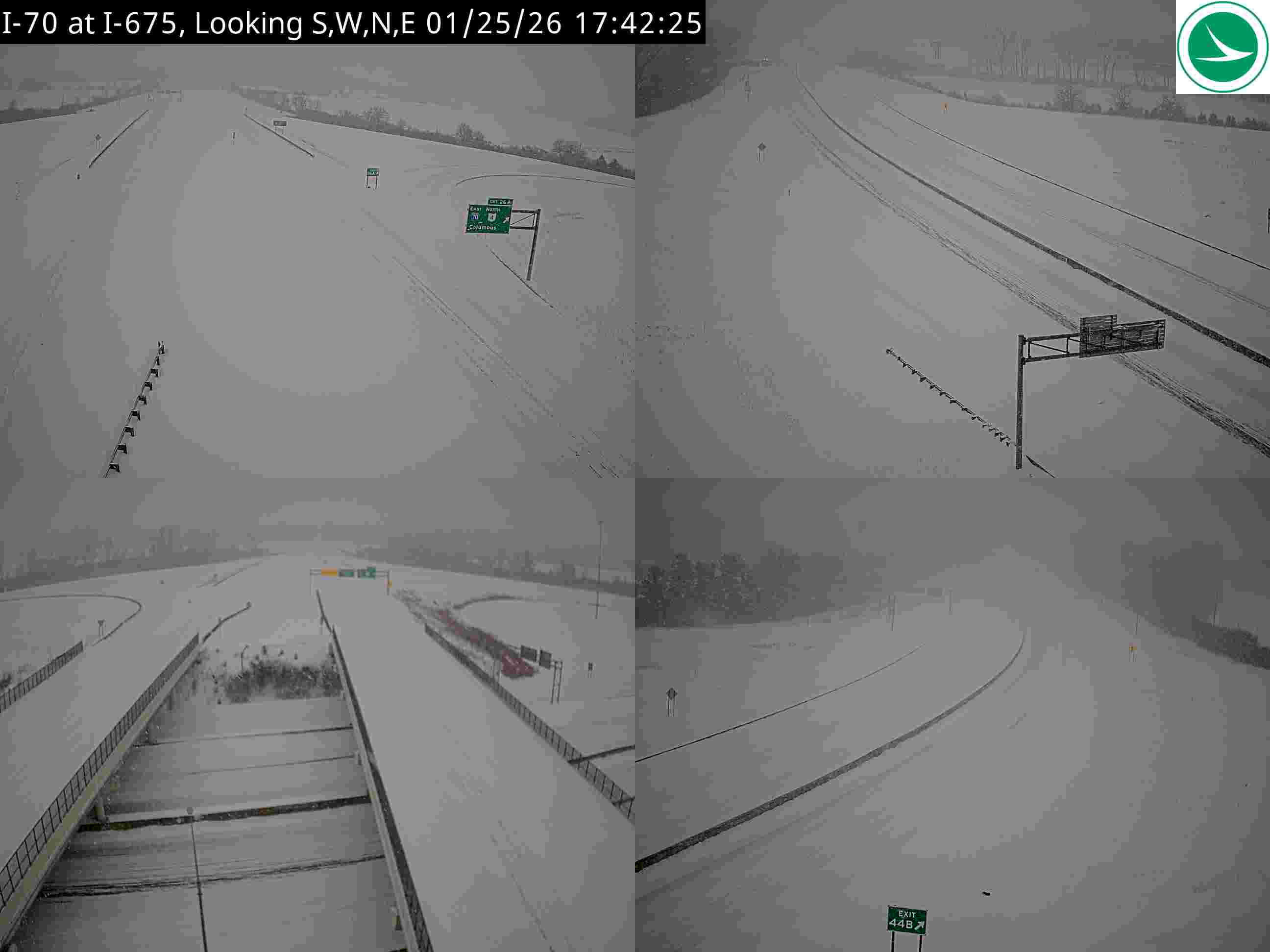
I-70 at I-675
Here's a concise analysis of the traffic camera image:
Road Conditions: Heavily snow-covered. Lanes are barely visible.
Traffic Flow: Very light/sparse. Only a few vehicles are visible in the distance.
Weather Visibility: Extremely poor due to heavy snowfall. Visibility appears limited to just a few car lengths.
Incidents/Observations: No visible incidents. Conditions suggest travel is strongly discouraged. It appears to be nighttime.
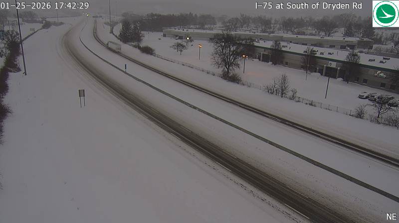
I-75 at South of Dryden Rd
Here's a concise analysis of the traffic camera image:
Road Conditions: Snow-covered; appears slushy/wet in travel lanes.
Traffic Flow: Moderate; vehicles spaced out but moving. A semi-truck visible in the center lane.
Weather Visibility: Low; significant snowfall reducing visibility. Gray/overcast conditions.
Incidents/Observations: No visible incidents. Road markings are partially obscured by snow. Conditions suggest potential travel hazards.
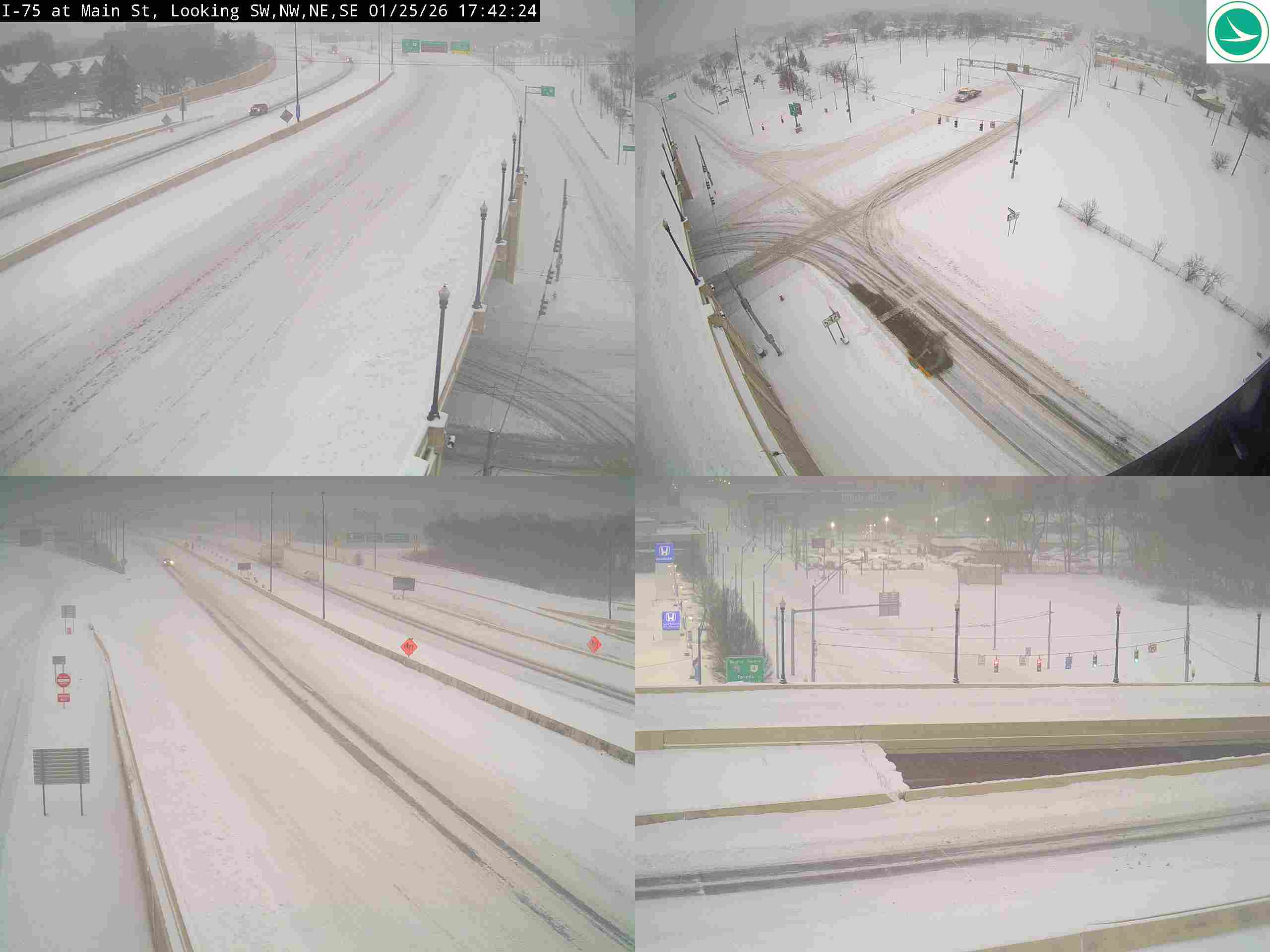
I-75 at Main St/SR-48
Here's a concise analysis of the traffic camera image:
Road Conditions: Heavily snow-covered; lanes are barely visible. Accumulation appears significant.
Traffic Flow: Very light; sparse vehicle presence in all lanes. Traffic is moving slowly.
Weather Visibility: Extremely poor due to heavy snowfall. Visibility is severely restricted.
Incidents/Observations: No visible incidents. Conditions suggest travel is hazardous. A possible stalled vehicle in the left lane in the upper portion of the image.
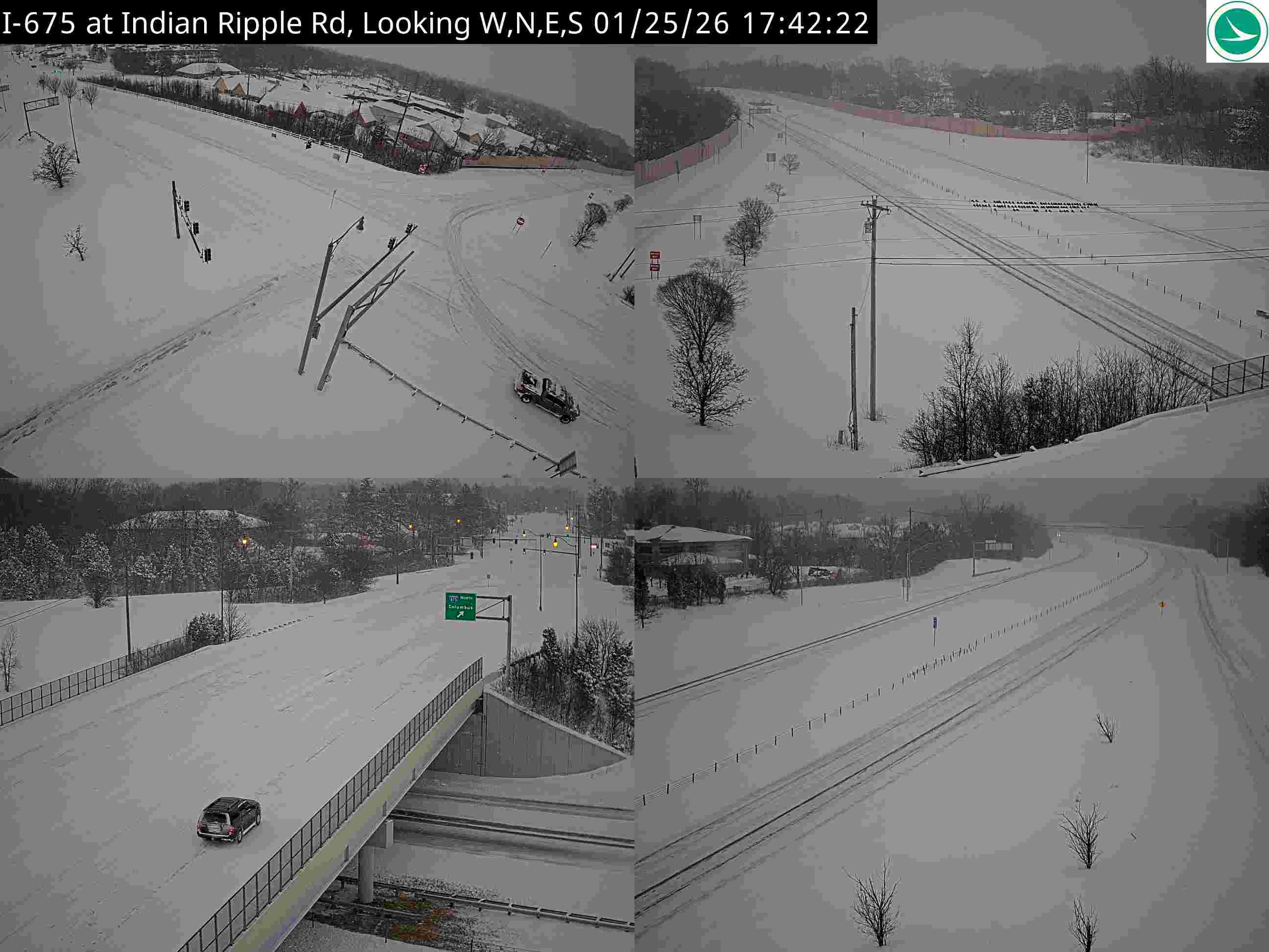
I-675 at Indian Ripple Rd
Here's a concise analysis of the traffic camera image:
Road Conditions: Heavily snow-covered. Lanes are visible but obscured by snow accumulation.
Traffic Flow: Light to moderate, spaced out vehicles in both directions. Traffic appears slowed due to conditions.
Weather Visibility: Reduced visibility due to snowfall. It appears to be actively snowing in the image.
Incidents/Observations: No visible incidents (accidents or disabled vehicles) are immediately apparent. A single vehicle is visible under the overpass in the lower left corner. Overall conditions suggest hazardous travel.
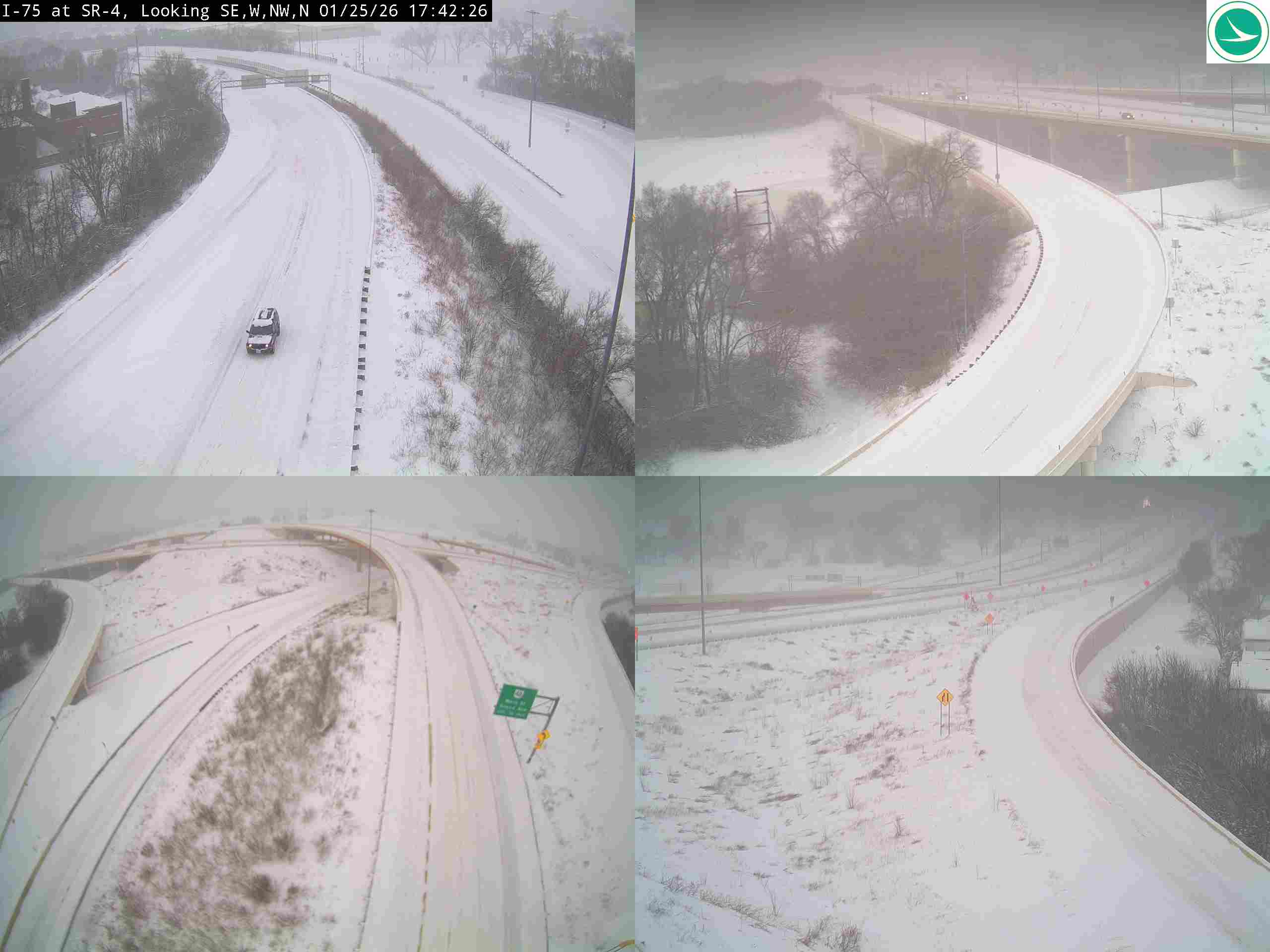
I-75 at SR-4
Here's a concise analysis of the traffic camera image:
Road Conditions: Heavily snow-covered; roads appear slick and hazardous.
Traffic Flow: Very light; only one vehicle visible in the upper left panel. Traffic appears sparse overall.
Weather Visibility: Poor; significant snowfall reduces visibility considerably. Whiteout conditions are likely in some areas.
Incidents/Observations: No visible incidents in the image. However, the conditions suggest travel is strongly discouraged due to safety concerns. The curve in the road in the upper right panel appears particularly dangerous in these conditions.
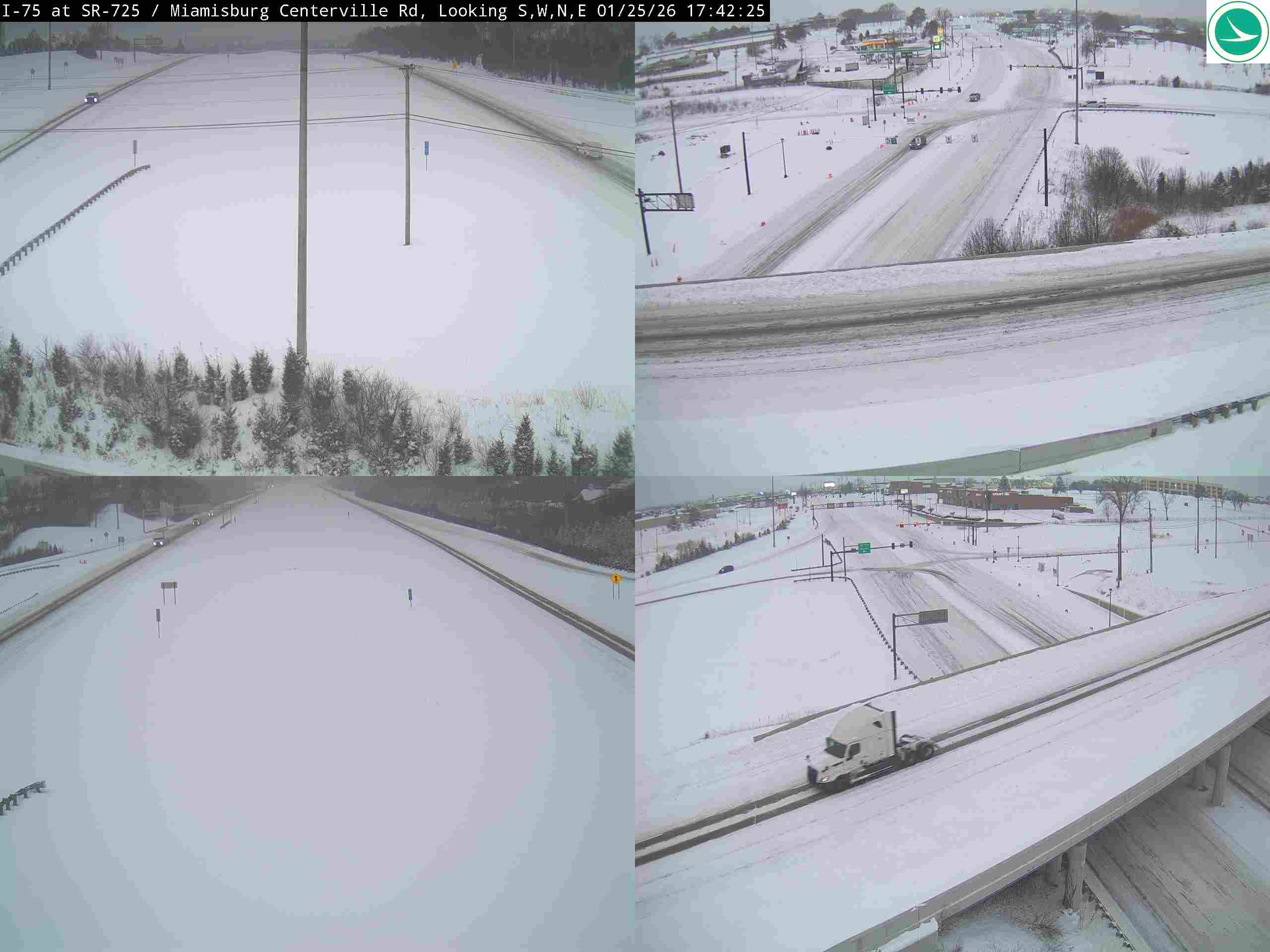
I-75 at SR-725/Miamisburg Centerville Rd
Here's a concise analysis of the traffic camera image:
Road Conditions: Snow-covered; lanes appear slushy/icy. Visibility is significantly reduced due to falling snow.
Traffic Flow: Moderate but slowing in both directions. Traffic density appears higher in the right lanes.
Weather Visibility: Very poor - heavy snowfall obscuring distant objects.
Incidents/Observations: No visible crashes or disabled vehicles in the immediate view. Guardrails are visible in the lower left corner. A semi-truck is visible in the lower right corner. Overall conditions suggest hazardous travel.
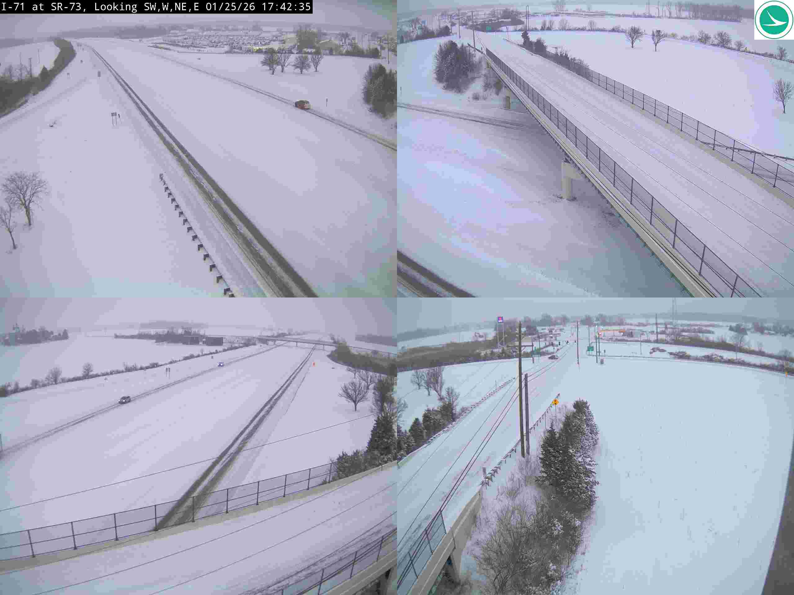
I-71 at SR-73
Here's a concise analysis of the traffic camera image:
Road Conditions: Heavily snow-covered. Lanes are visible but obscured by snow accumulation. Likely icy conditions.
Traffic Flow: Light to moderate traffic in both directions. Vehicles appear spaced apart.
Weather Visibility: Poor visibility due to falling/accumulated snow. It's actively snowing in the image.
Incidents/Observations: No visible incidents (no stopped vehicles or crashes). Guardrails are visible in some panels. Overall conditions suggest travel is hazardous.
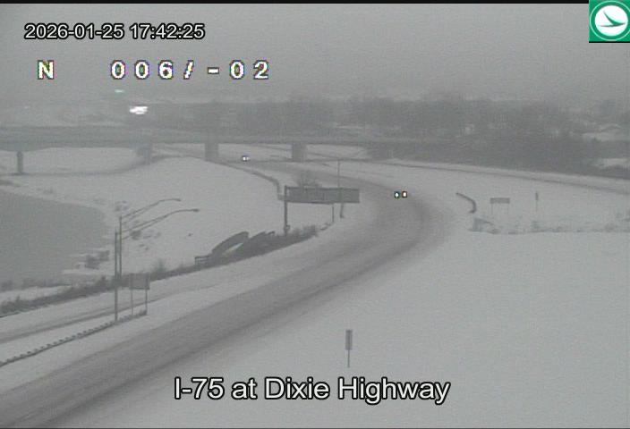
I-75 at Dixie Highway
Here's a concise analysis of the traffic camera image:
Road Conditions: Heavily snow-covered; visibility significantly reduced. Road appears slick.
Traffic Flow: Light to moderate, but spaced out due to conditions.
Weather Visibility: Very poor due to heavy snowfall. Whiteout conditions likely.
Incidents/Observations: A vehicle appears partially off the road in the right shoulder, possibly stalled or involved in a minor incident. Overall conditions suggest hazardous travel.
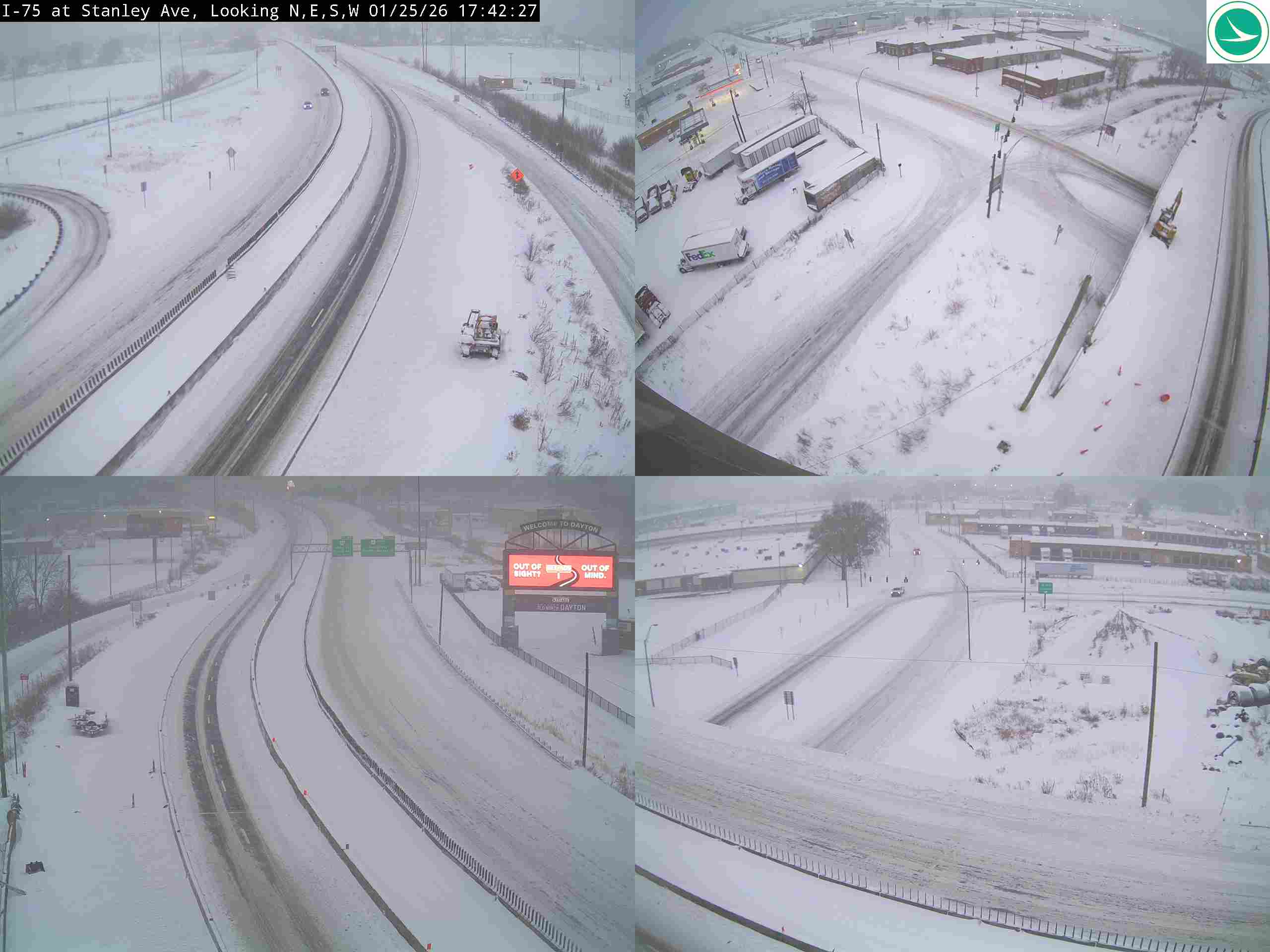
I-75 at Stanley Ave
Here's a concise analysis of the traffic camera image:
Road Conditions: Heavily snow-covered; lanes are barely visible. Accumulation appears significant.
Traffic Flow: Light to moderate, but slowed due to snow. Vehicles are spaced apart.
Weather Visibility: Very poor due to heavy snowfall. Whiteout conditions likely in some areas.
Incidents/Observations: No visible crashes or disabled vehicles in the frame. A FedEx truck is visible in the right lane. Overall conditions suggest travel is hazardous.
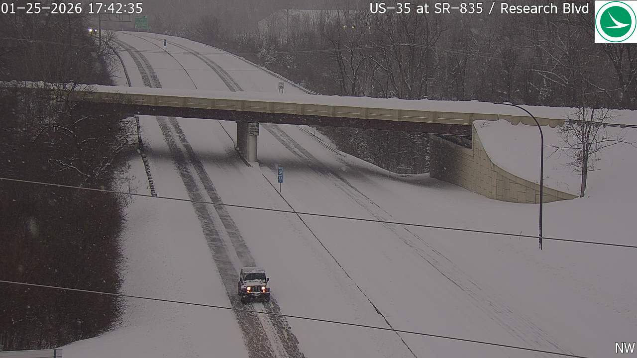
US-35 at SR-835 / Research Blvd
Here's a concise analysis of the traffic camera image:
Road Conditions: Heavily snow-covered. Visible tire tracks suggest recent travel but snow accumulation is significant.
Traffic Flow: Moderate but spaced out. Traffic appears to be moving, but slower due to snow.
Weather Visibility: Low visibility due to falling snow. It appears to be actively snowing.
Incidents/Observations: No visible incidents. A red pickup truck is visible in the foreground. Overall conditions suggest hazardous driving.
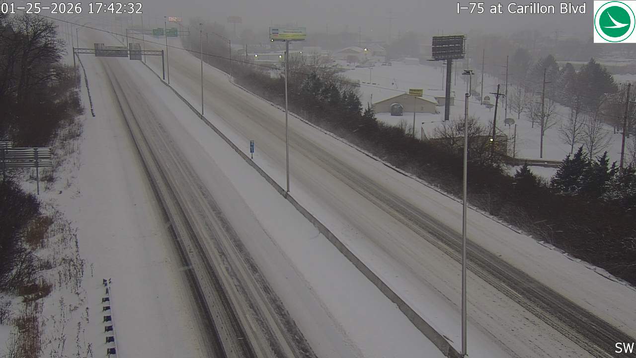
I-75 at Carillon Blvd
Here's a concise analysis of the traffic camera image:
Road Conditions: Heavily snow-covered; lanes are barely visible. Road surface appears slick.
Traffic Flow: Light to moderate traffic in both directions. Vehicles appear spaced apart.
Weather Visibility: Very poor due to heavy snowfall. Visibility is significantly reduced.
Incidents/Observations: No visible incidents. Conditions suggest travel is hazardous.
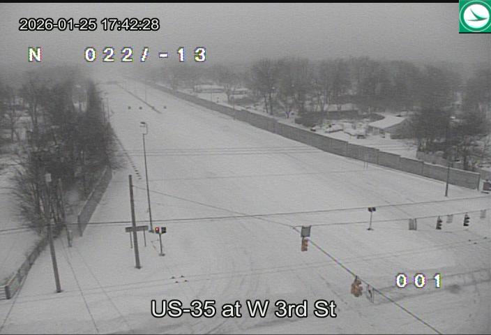
US-35 at W 3rd St
Here's a concise analysis of the traffic camera image:
Road Conditions: Heavily snow-covered. Visibility appears significantly reduced due to snowfall.
Traffic Flow: Light to moderate traffic in both directions. Vehicles appear spaced apart.
Weather Visibility: Very poor due to heavy snowfall. It's difficult to see details beyond a short distance.
Incidents/Observations: No visible incidents or stalled vehicles. Overall conditions suggest hazardous travel.
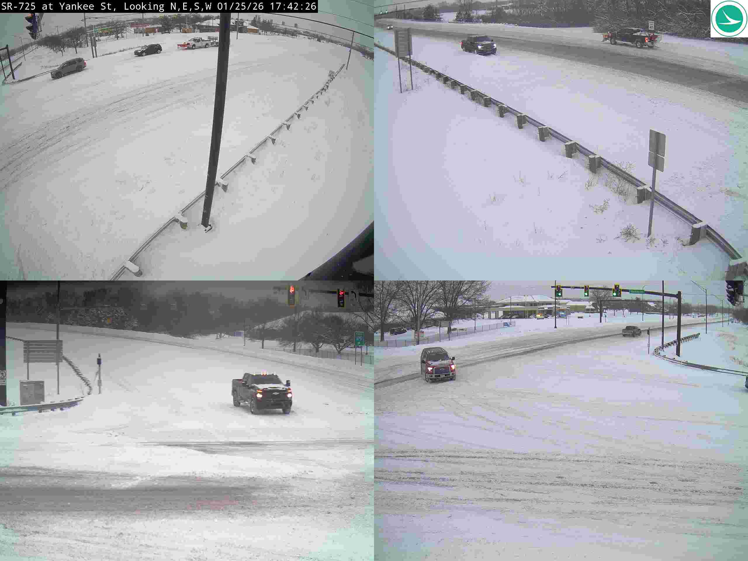
SR-725 at Yankee St
Here's a concise analysis of the traffic camera image:
Road Conditions: Heavily snow-covered. Roads appear slick/snow-packed.
Traffic Flow: Moderate but slowed due to snow. Visible vehicles are spaced apart.
Weather Visibility: Poor - significant snowfall reducing visibility. Whiteout conditions likely in some areas.
Incidents/Observations: No visible crashes or disabled vehicles in the frame. Traffic signals are functioning. A dark SUV is stopped at a red light in the lower left quadrant.
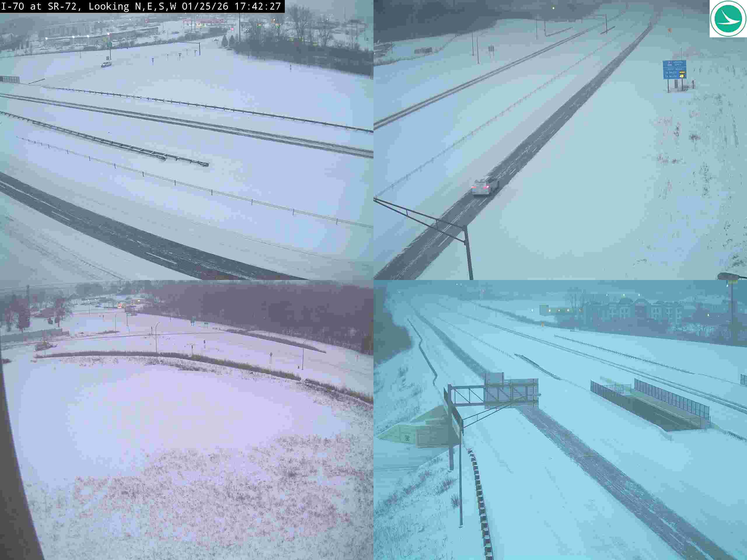
I-70 at SR-72 / Limestone St
Here's a concise analysis of the traffic camera image:
Road Conditions: Heavily snow-covered; lanes are visible but obscured by snow. Accumulation appears significant.
Traffic Flow: Light to moderate; vehicles are spaced apart but moving. Traffic appears slower than usual.
Weather Visibility: Poor; visibility is significantly reduced due to snowfall. A whiteout condition seems possible.
Incidents/Observations: No visible incidents (no stopped vehicles or debris). Snow accumulation suggests recent or ongoing snowfall. Overhead sign visibility is also reduced.
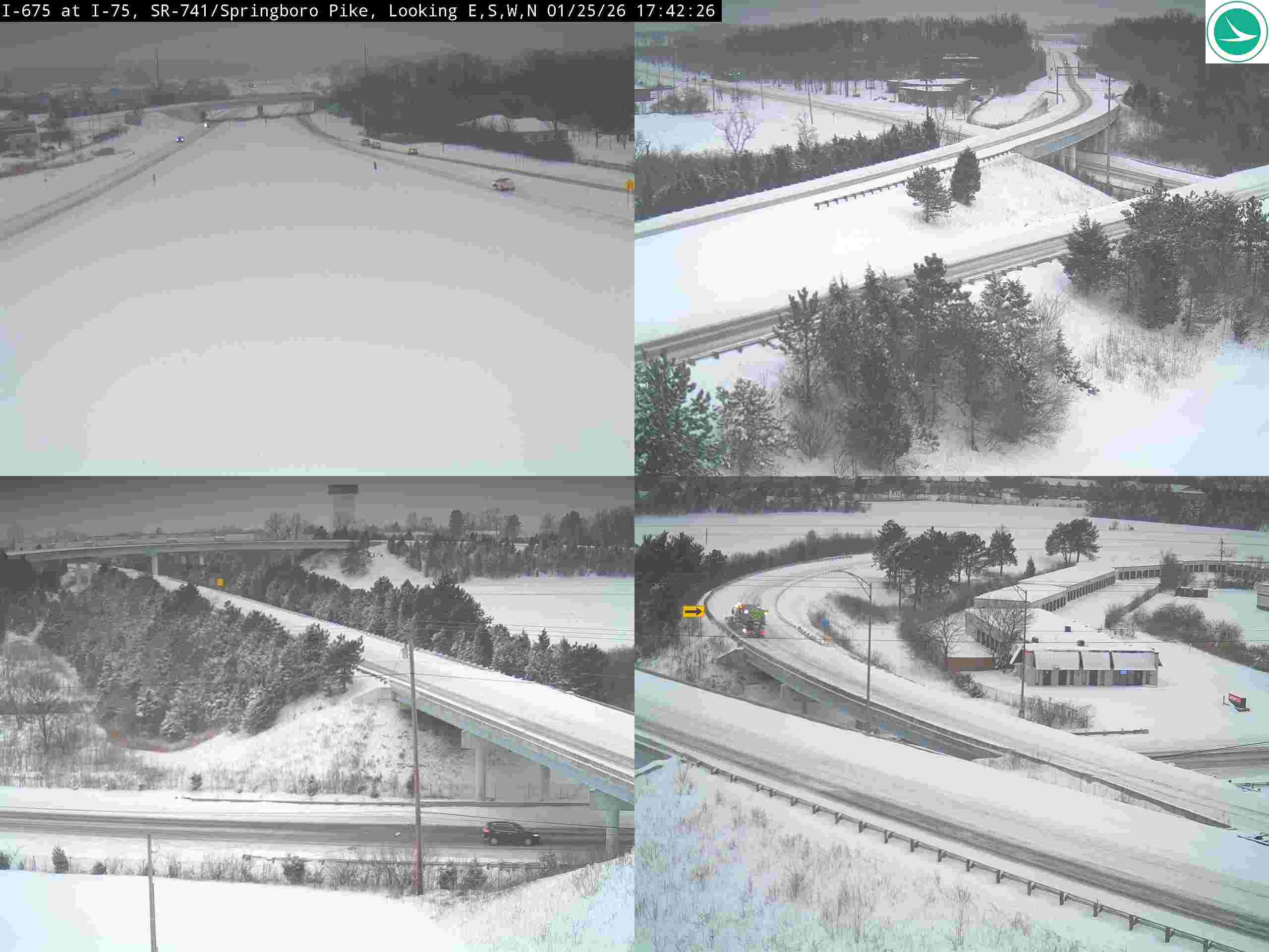
I-675 at I-75, SR-741/Springboro Pike
Here's a concise analysis of the traffic camera image:
Road Conditions: Heavily snow-covered. Roads appear slick and visibility reduced due to accumulation.
Traffic Flow: Moderate but slowed due to snow. Cars are spaced out but moving.
Weather Visibility: Poor - significant snowfall obscuring distant objects. Whiteout conditions likely in some areas.
Incidents/Observations: A yellow arrow indicates a lane closure/divergence in the lower left panel. A red vehicle is visible in the lower left panel. There appears to be a stalled vehicle in the lower right panel. Overall conditions suggest hazardous travel.
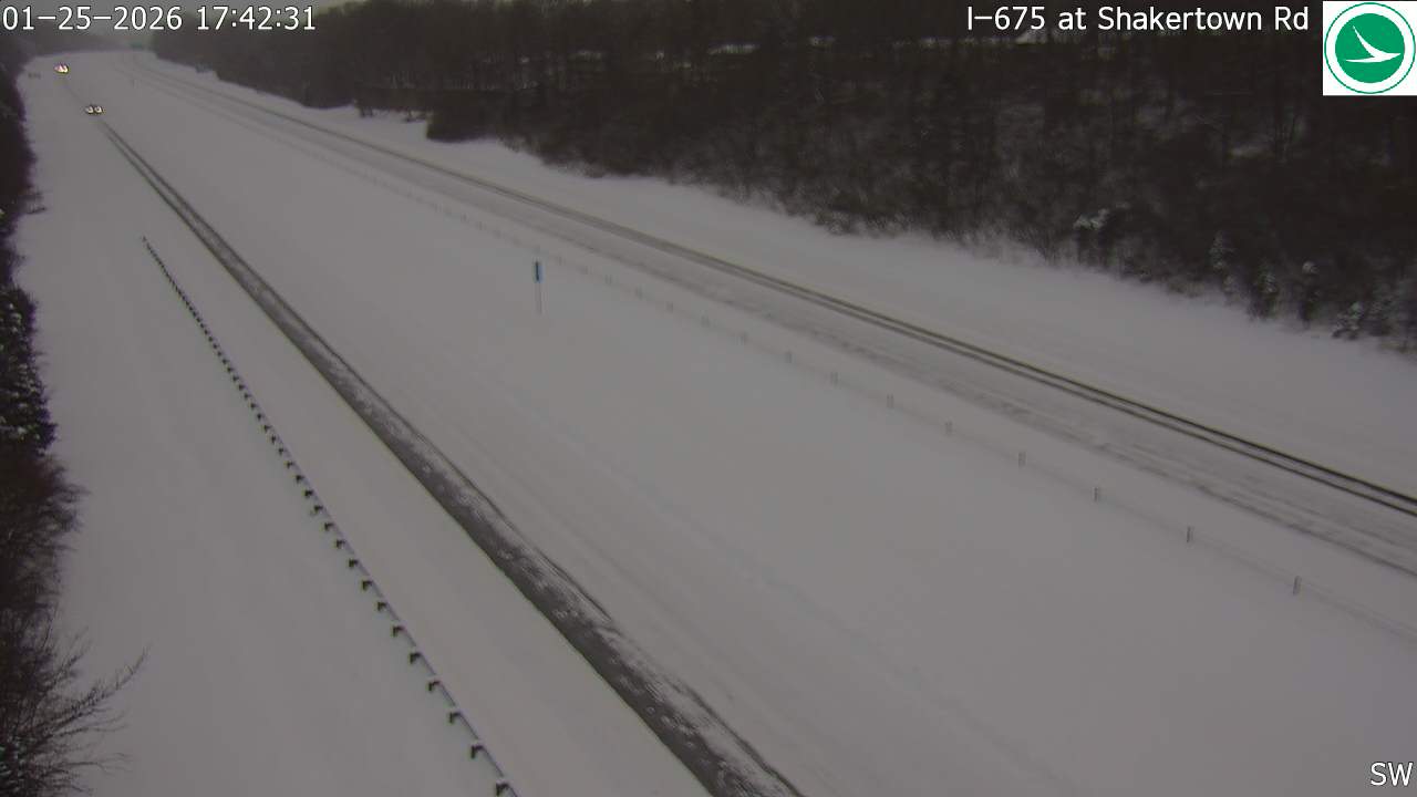
I-675 at Shakertown Rd
Here's a concise analysis of the traffic camera image:
Road Conditions: Heavily snow-covered. Road surface appears slick.
Traffic Flow: Light to moderate, but spaced out due to conditions.
Weather Visibility: Significantly reduced due to falling snow. Visibility estimated at under ¼ mile.
Incidents/Observations: No visible incidents in the immediate view. Conditions suggest travel is hazardous. A lone vehicle can be seen in the distance.
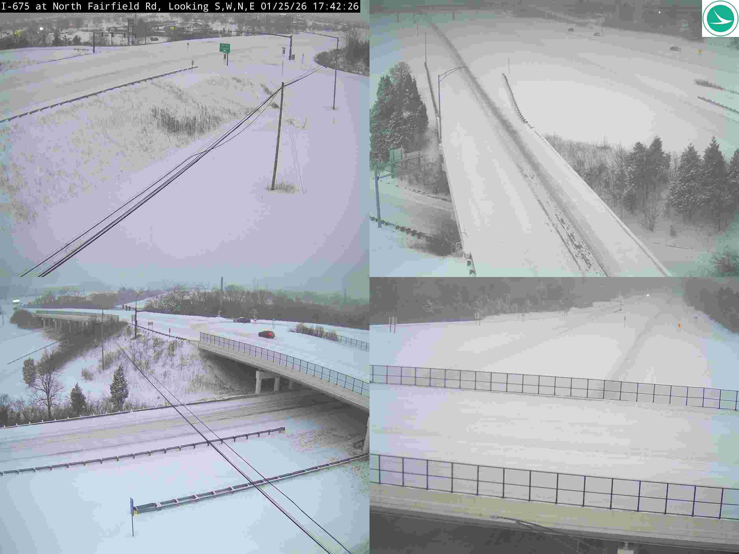
I-675 at North Fairfield Rd
Here's a concise analysis of the traffic camera image:
Road Conditions: Heavily snow-covered. Lanes are barely visible in some areas. Accumulation appears substantial.
Traffic Flow: Very light. Only a few vehicles are visible in the distance. Traffic is moving slowly.
Weather Visibility: Poor due to falling/accumulated snow. Visibility is significantly reduced.
Incidents/Observations: No visible incidents in the image. However, the conditions suggest travel is hazardous. The bridge appears clear but surrounding areas are covered in snow.
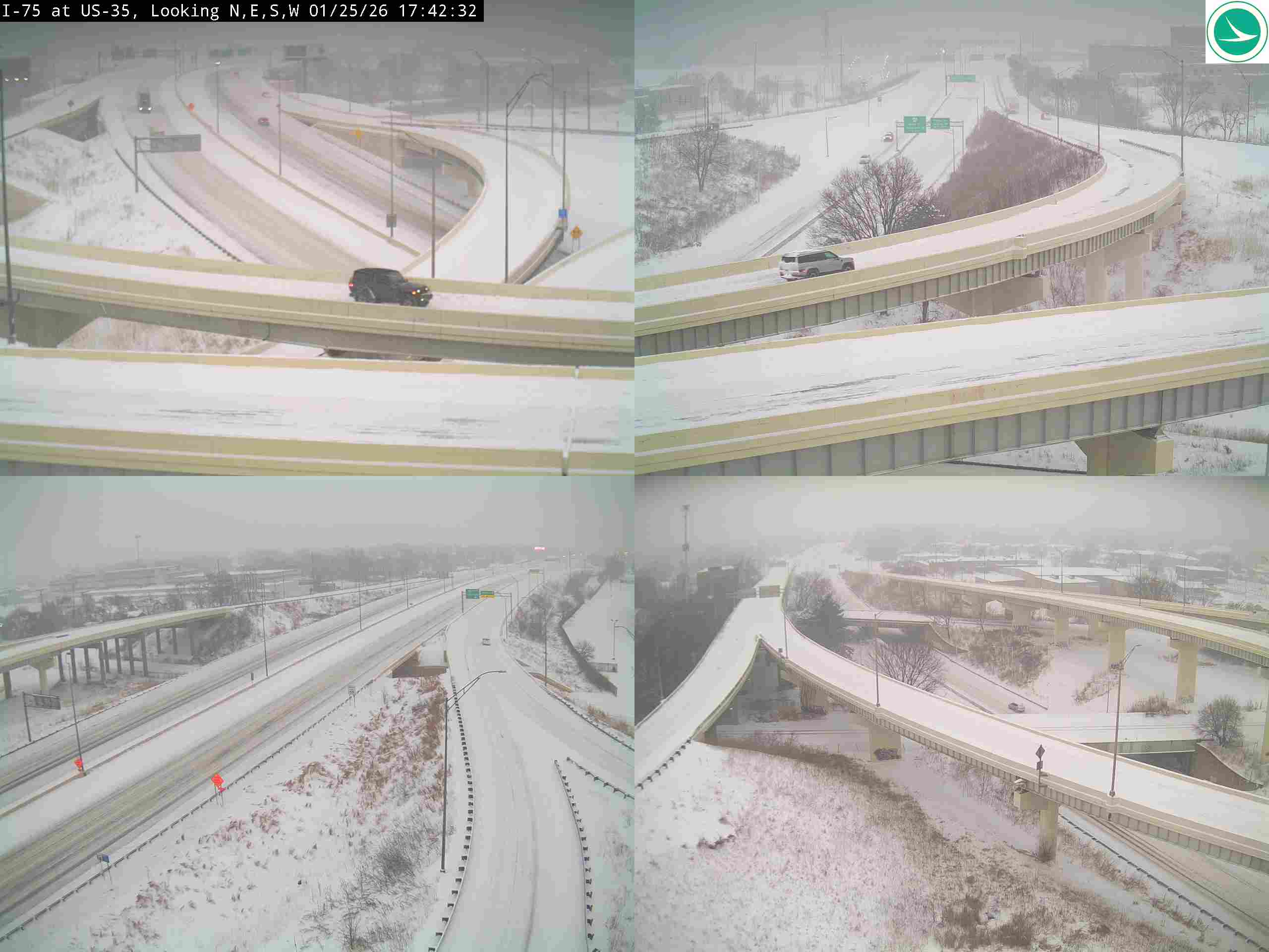
I-75 at US-35
Here's a concise analysis of the traffic camera image:
Road Conditions: Heavily snow-covered. Lanes appear passable but visibility is significantly reduced due to snowfall.
Traffic Flow: Moderate to light traffic in all lanes. Vehicles are spaced apart.
Weather Visibility: Very poor - heavy snowfall creates whiteout conditions. Visibility is limited to short distances.
Incidents/Observations: No visible incidents in the image. Snow accumulation suggests recent or ongoing snowfall. Road markings are obscured.
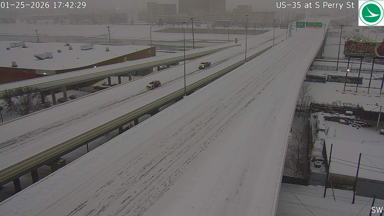
US-35 at S Perry St
Here's a concise analysis of the traffic camera image:
Road Conditions: Heavily snow-covered. Roads appear slick and potentially hazardous.
Traffic Flow: Light to moderate traffic in both directions. Vehicles are spaced apart.
Weather Visibility: Reduced visibility due to falling snow. It appears overcast.
Incidents/Observations: No visible incidents in the immediate frame. Snow accumulation is significant on all surfaces. El Toro restaurant signage visible in background.
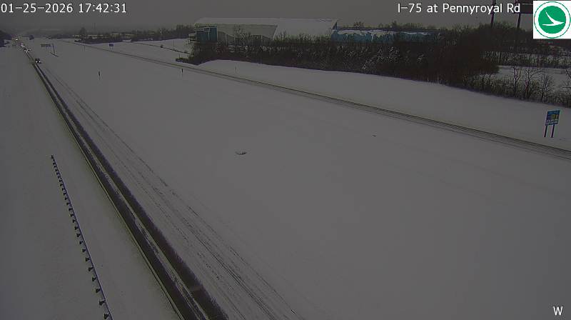
I-75 at Pennyroyal Rd
Here's a concise analysis of the traffic camera image:
Road Conditions: Heavily snow-covered; appears icy/slushy. Visibility is significantly reduced due to snowfall.
Traffic Flow: Moderate but spaced out; vehicles appear to be traveling slowly.
Weather Visibility: Very poor - heavy snowfall obscuring distant objects.
Incidents/Observations: No visible crashes or disabled vehicles in the immediate view. Overall conditions suggest hazardous travel.
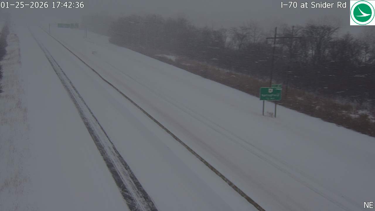
I-70 at Snider Rd
Here's a concise analysis of the traffic camera image:
Road Conditions: Heavily snow-covered; visibility of lane markings is poor. Likely icy/slippery conditions.
Traffic Flow: Very light; only a few vehicles visible in the distance.
Weather Visibility: Low visibility due to heavy snowfall. Whiteout conditions appear possible.
Incidents/Observations: No visible incidents. Overall conditions suggest travel is hazardous.
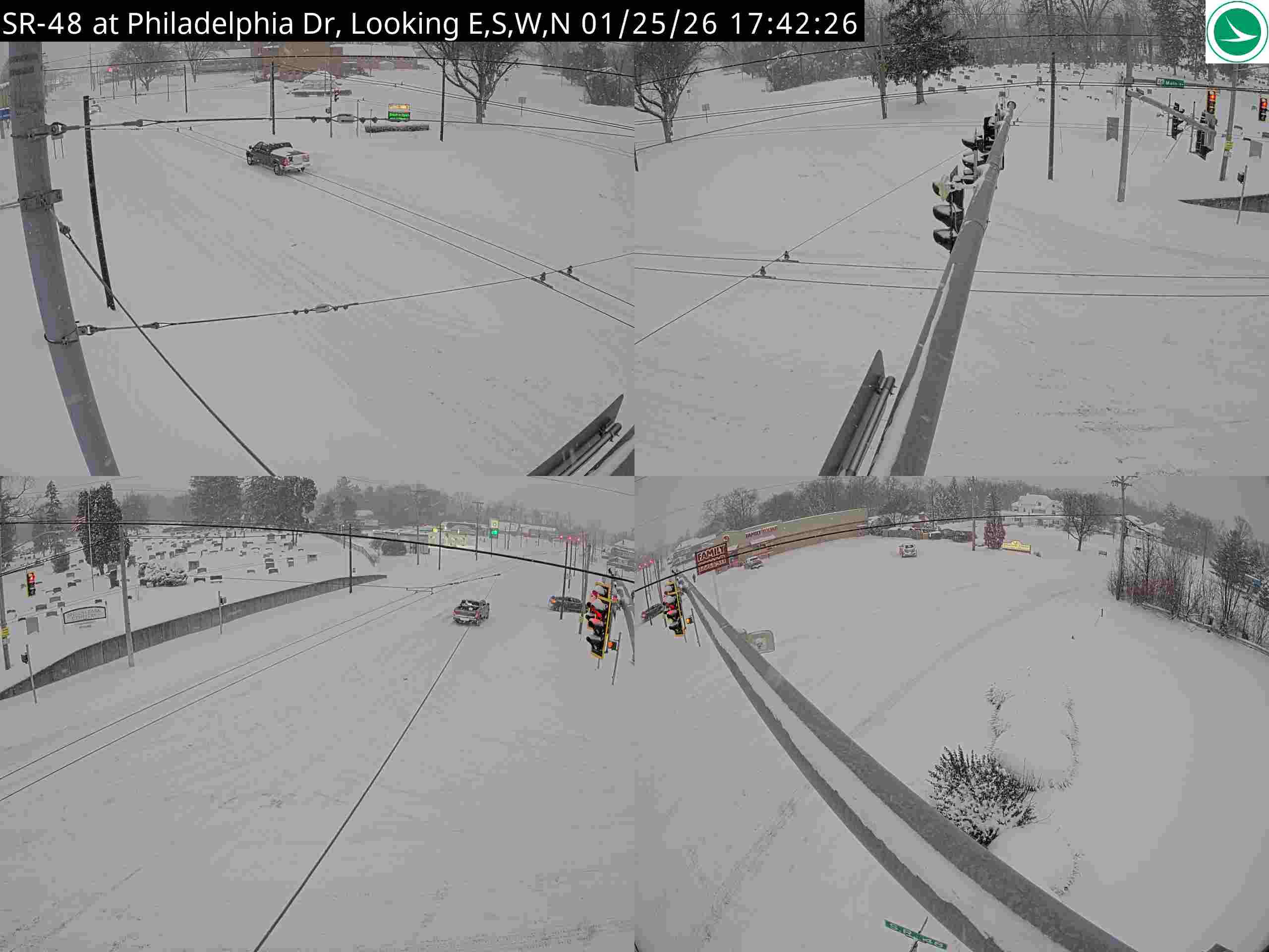
SR-48 at Philadelphia Dr, NE corner
Here's a concise analysis of the traffic camera image:
Road Conditions: Heavily snow-covered. Roads appear slick and visibility is significantly reduced.
Traffic Flow: Light to moderate traffic in both directions. Vehicles appear spaced out, likely due to the weather conditions.
Weather Visibility: Very poor due to heavy snowfall. Whiteout conditions are likely in some areas.
Incidents/Observations: No visible accidents or disabled vehicles in the immediate view. However, the overall conditions suggest travel is hazardous. The distinctive bridge structure in the image is partially obscured by snow.
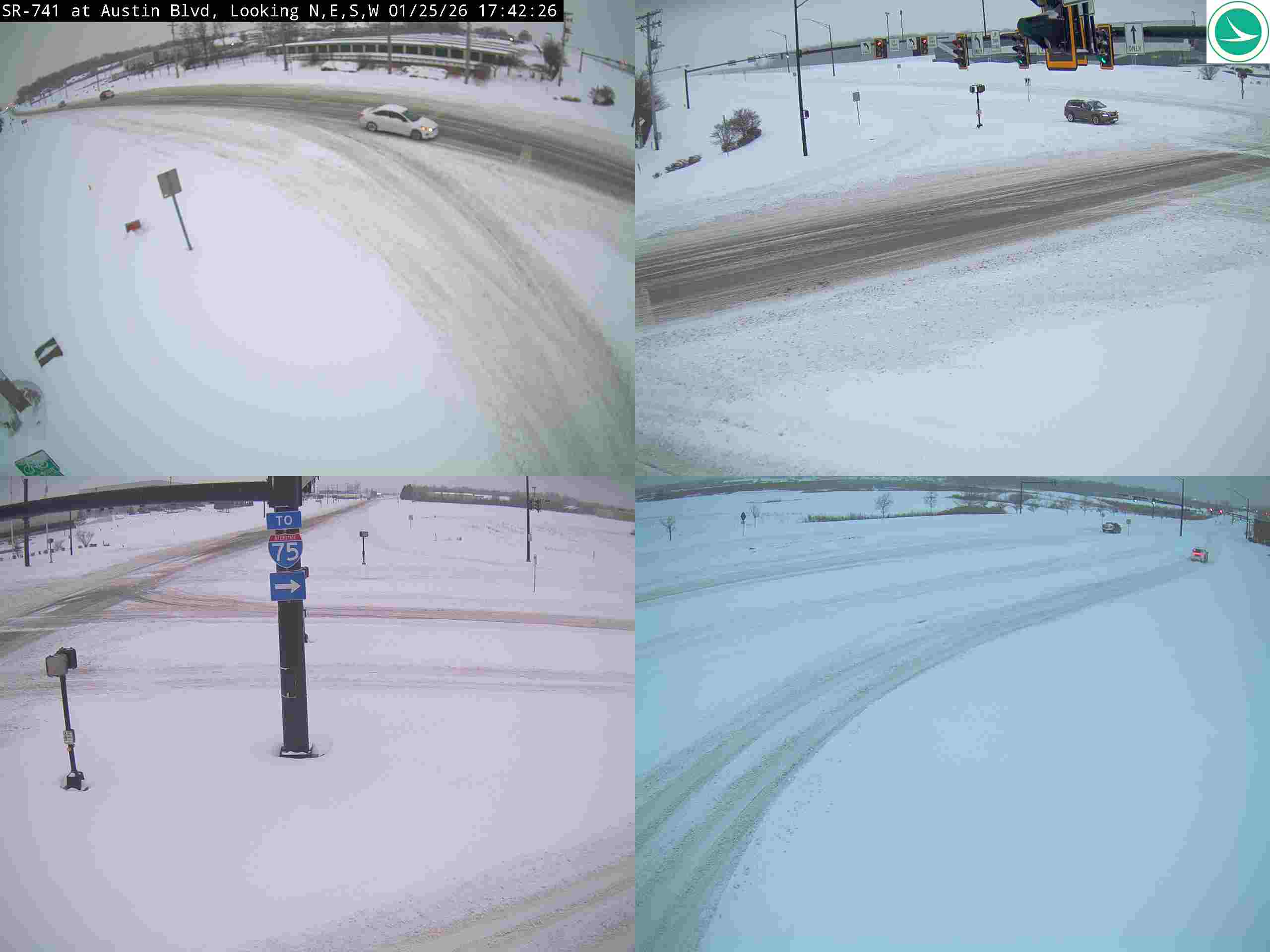
SR-741 at Austin Blvd
Here's a concise analysis of the traffic camera image:
Road Conditions: Heavily snow-covered. Roads appear slick and impassable in some areas. Tire tracks indicate recent vehicle passage but also highlight the snow accumulation.
Traffic Flow: Very light. Only a few vehicles are visible in the distance. Traffic is significantly reduced due to the weather conditions.
Weather Visibility: Poor. Heavy snowfall reduces visibility considerably. It's difficult to see details beyond a short distance.
Incidents/Observations: No visible incidents. However, the conditions clearly indicate hazardous travel. A sign pointing towards Interstate 75 is visible in one quadrant.
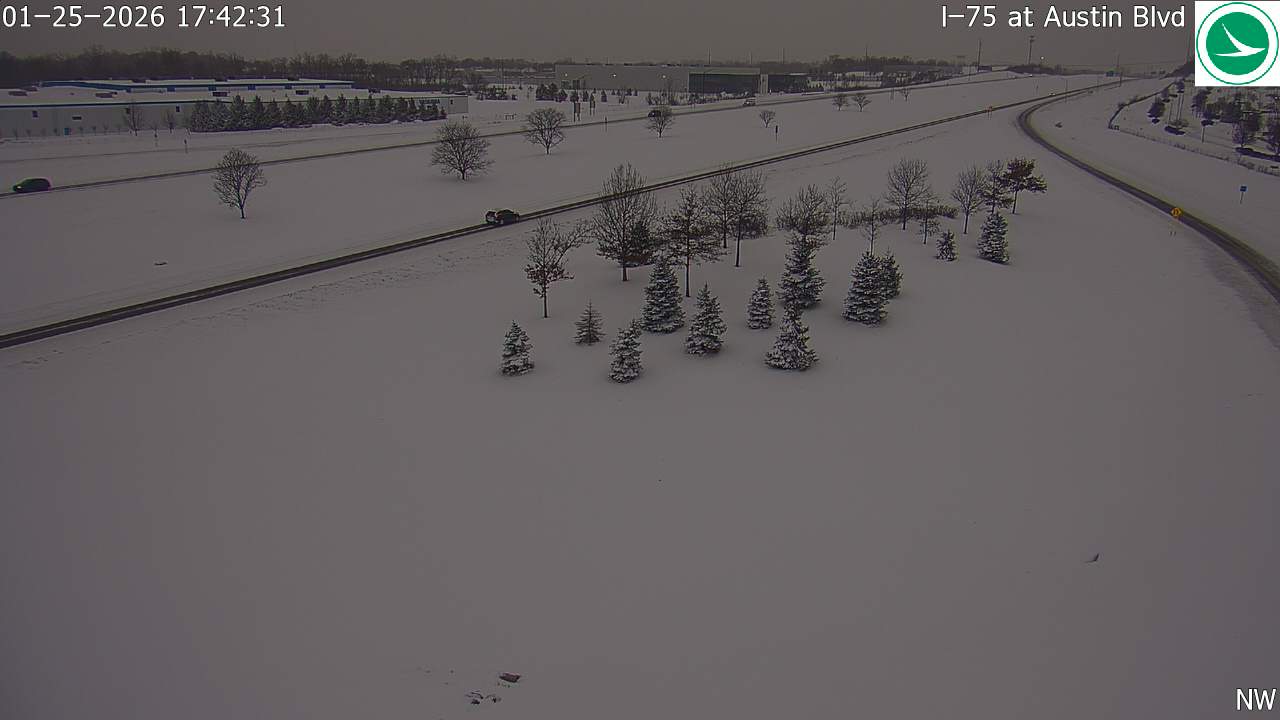
I-75 at Austin Blvd
Here's a concise analysis of the traffic camera image:
Road Conditions: Heavily snow-covered. Roads appear slick/icy.
Traffic Flow: Moderate but spaced out. Traffic appears slower than usual due to conditions.
Weather Visibility: Reduced due to snowfall. Visibility appears limited.
Incidents/Observations: No visible incidents in the immediate view. Snow accumulation is significant. NW wind direction indicated.
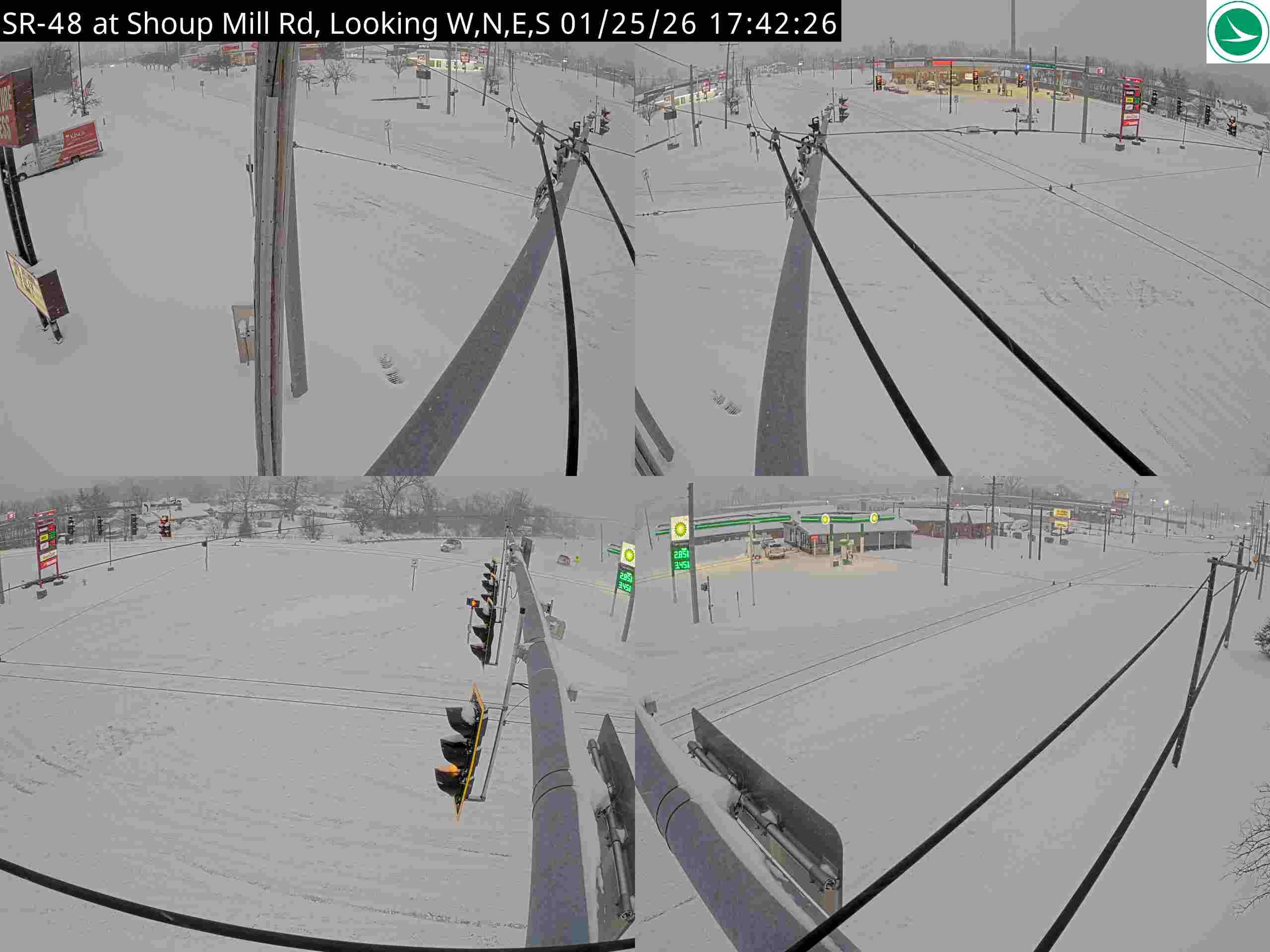
SR-48 at Shoup Mill Rd, SW Corner
Here's a concise analysis of the traffic camera image:
Road Conditions: Heavily snow-covered. Roads appear slick and visibility is significantly reduced.
Traffic Flow: Light to moderate traffic in both directions. Vehicles are spaced apart, likely due to the weather conditions.
Weather Visibility: Very poor due to heavy snowfall. A whiteout effect is visible in many areas.
Incidents/Observations: No visible incidents in the immediate view. However, the conditions suggest a high risk of accidents. Traffic signals are visible and functioning. A gas station/convenience store is visible in the background.
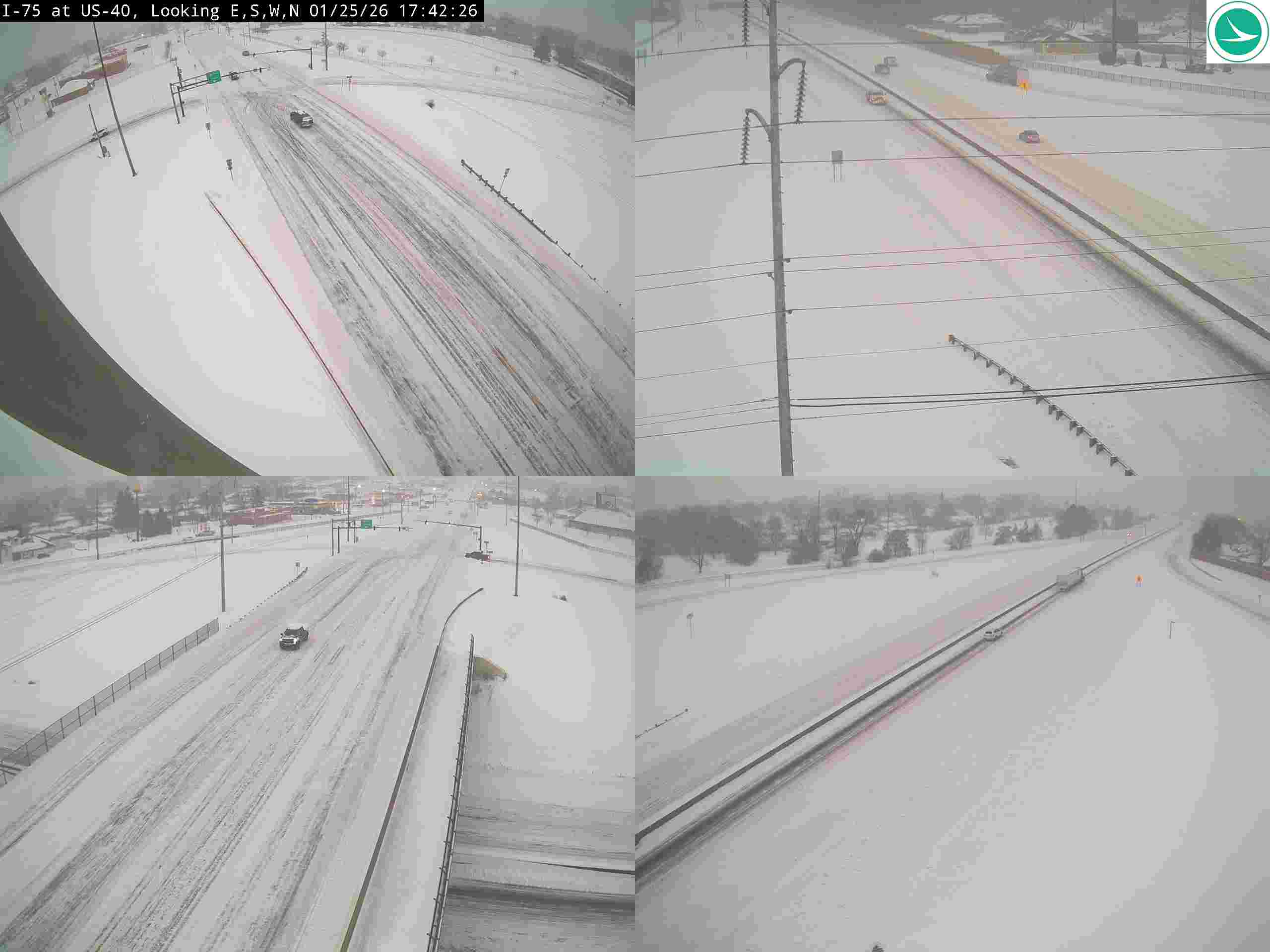
I-75 at US-40
Here's a concise analysis of the traffic camera image:
Road Conditions: Roads appear covered in snow/slush, indicating icy/slippery conditions.
Traffic Flow: Moderate traffic flow in both directions. Some congestion visible in the left panels.
Weather Visibility: Low visibility due to snowfall/weather conditions.
Incidents/Observations: A vehicle appears stopped in the right shoulder in the upper right panel. Possible minor congestion forming around it. Overall conditions suggest hazardous travel.
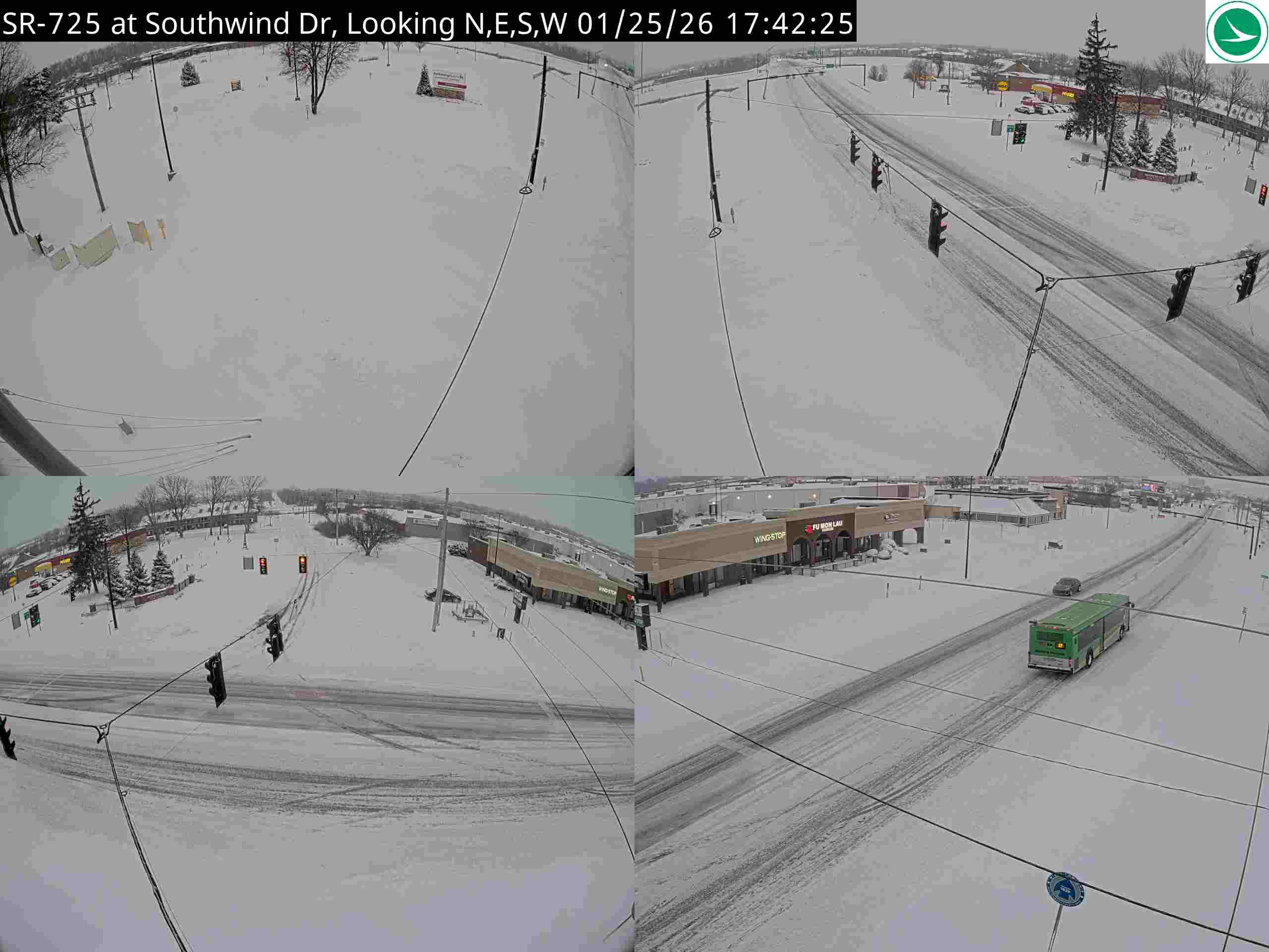
SR-725 at Southwind Dr
Here's a concise analysis of the traffic camera image:
Road Conditions: Heavily snow-covered. Lanes are barely visible, suggesting significant accumulation.
Traffic Flow: Light to moderate, but appears slowed due to snow. Vehicles are spaced out.
Weather Visibility: Poor - snow reduces visibility significantly. It appears to be actively snowing.
Incidents/Observations: No obvious crashes or disabled vehicles are visible. A green truck is visible in the right lane. Traffic signals are functioning. Overall conditions suggest hazardous travel.
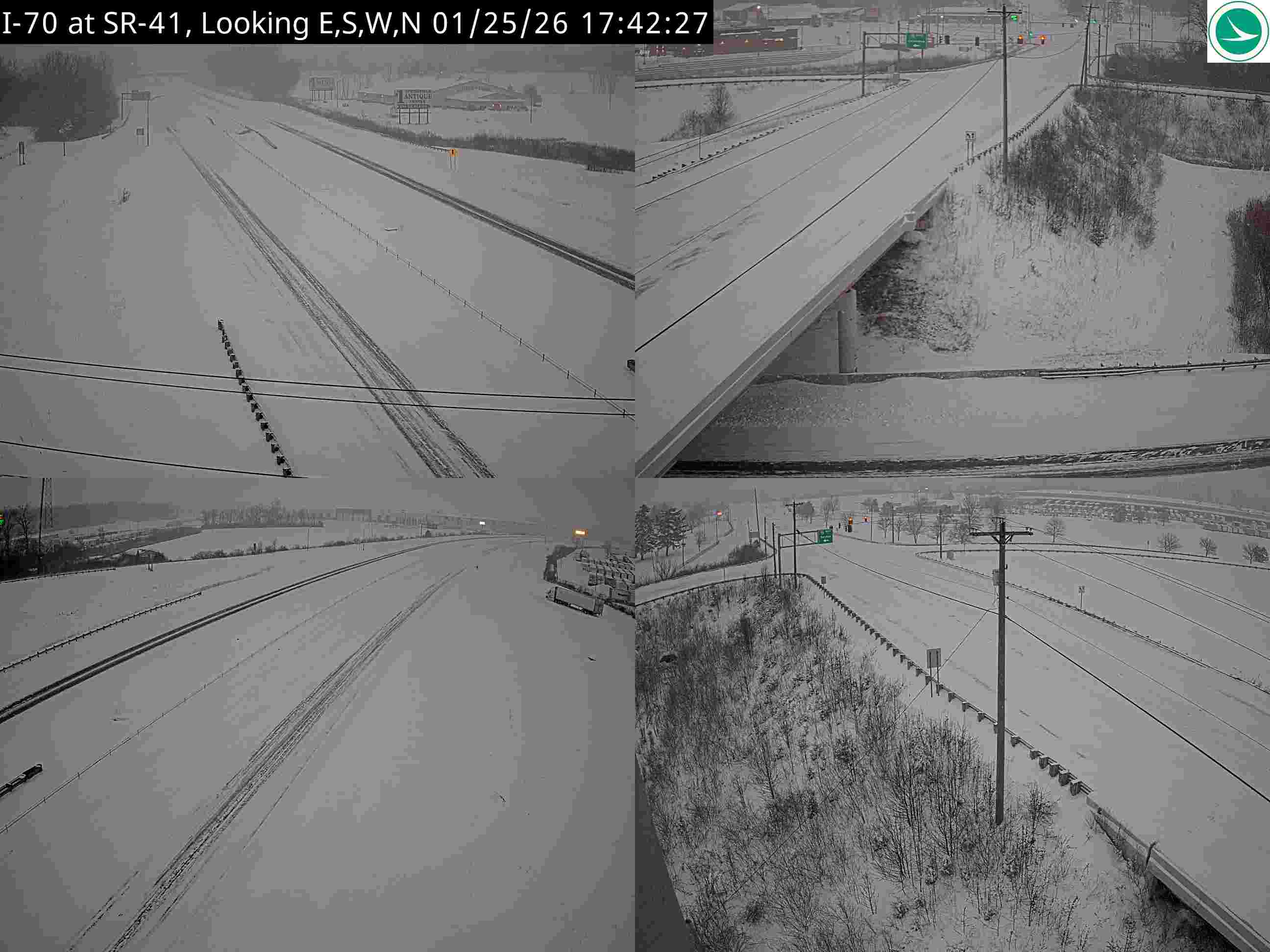
I-70 at SR-41
Here's a concise analysis of the traffic camera image:
Road Conditions: Roads appear covered in snow/ice, creating hazardous conditions. Visible slush/snow accumulation in lanes.
Traffic Flow: Moderate traffic flow in both directions. Some spacing between vehicles suggests slower speeds.
Weather Visibility: Low visibility due to snowfall/snow haze. Contrast is low in the image, indicating overcast/poor lighting.
Incidents/Observations: A vehicle is stopped on the shoulder in one of the panels, potentially disabled or involved in a minor incident. Overhead signs are partially obscured by snow.
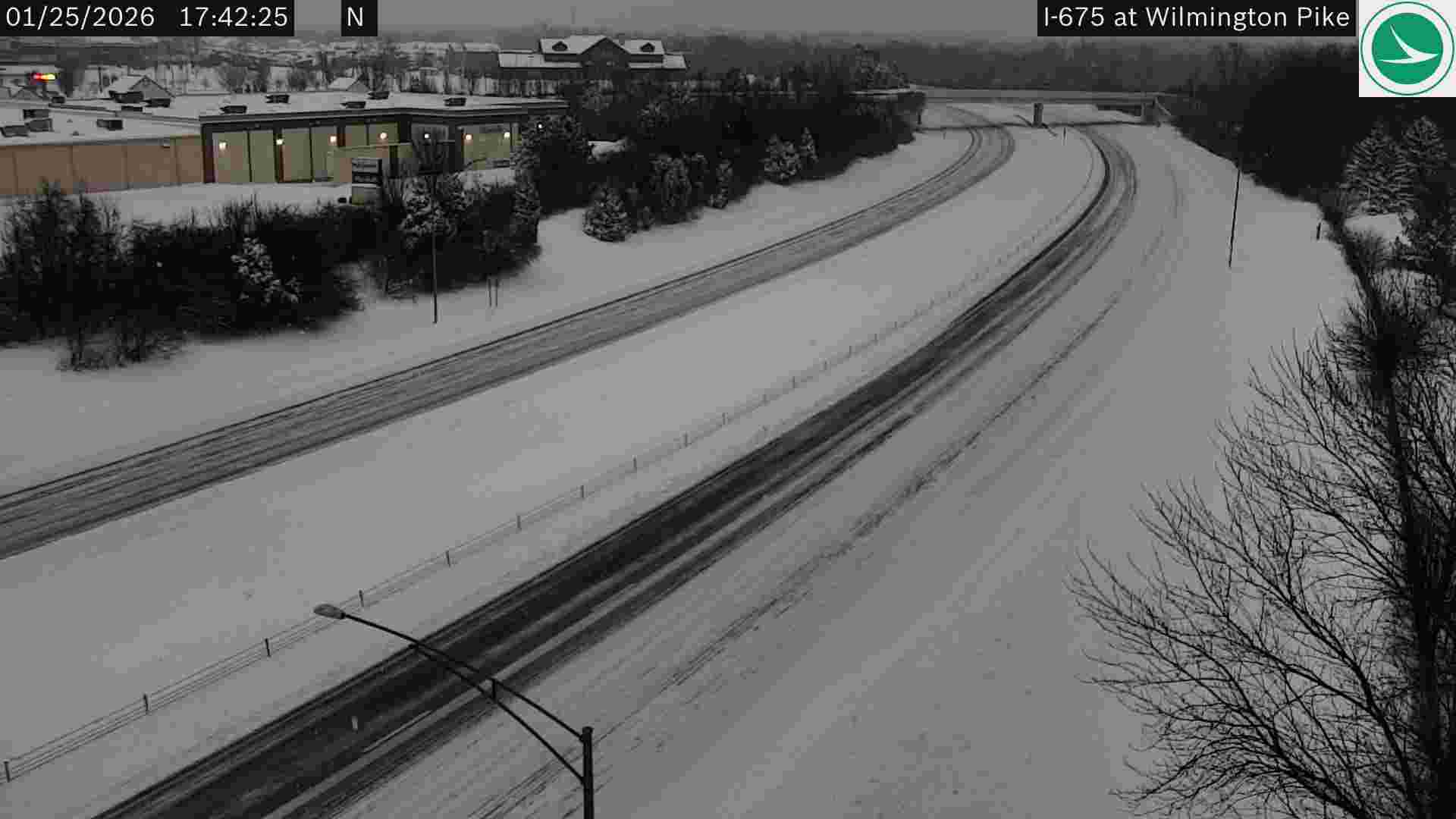
I-675 at Wilmington Pike
Here's a concise analysis of the traffic camera image:
Road Conditions: Roads appear covered in snow/slush, indicating icy/snowy conditions. Tire tracks suggest some traffic has already traversed the area.
Traffic Flow: Moderate traffic flow in both directions. Some spacing between vehicles.
Weather Visibility: Reduced visibility due to snowfall/weather conditions. It appears overcast.
Incidents/Observations: No visible incidents (accidents or stalled vehicles) in the frame. Overall conditions suggest travel may be hazardous.
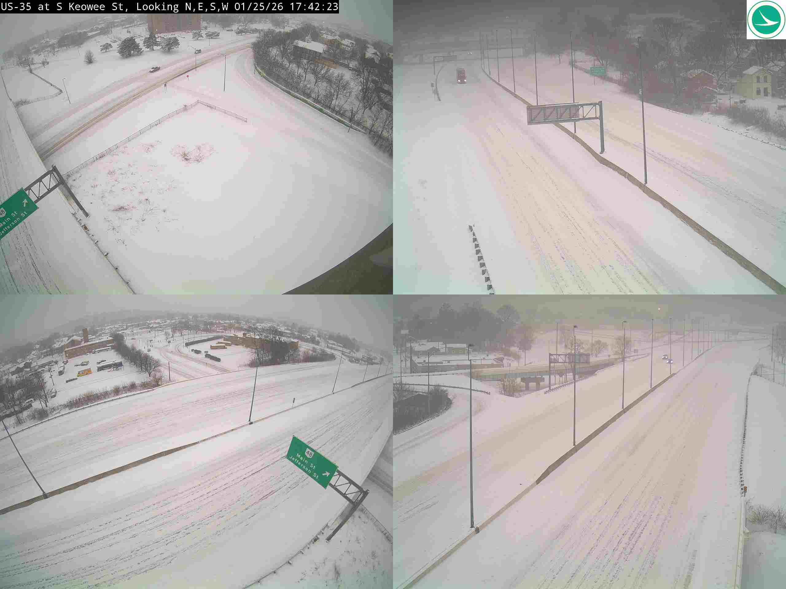
US-35 at S Keowee St
Here's a concise analysis of the traffic camera image:
Road Conditions: Heavily snow-covered. Roads appear slick and potentially icy.
Traffic Flow: Light to moderate, but vehicles are spaced apart suggesting cautious driving.
Weather Visibility: Reduced due to snowfall. Visibility appears moderate but impacted by falling snow.
Incidents/Observations: No visible accidents or stalled vehicles. Overhead signage is partially obscured by snow. Overall conditions suggest hazardous travel.
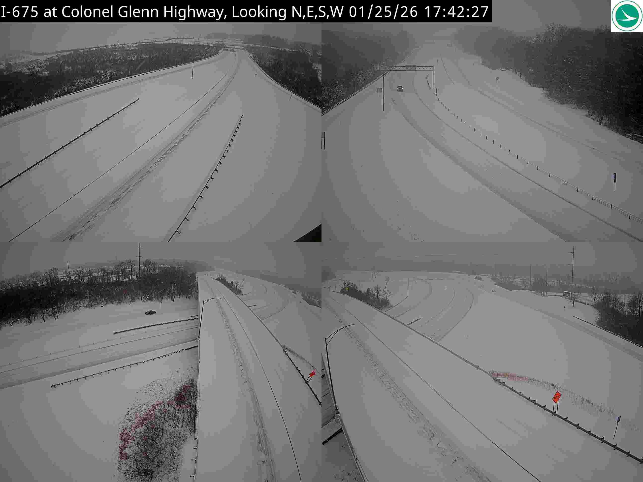
I-675 at Colonel Glenn Highway
Here's a concise analysis of the traffic camera image:
Road Conditions: Heavily snow-covered. Roads appear slick and visibility is reduced due to snow accumulation.
Traffic Flow: Light traffic volume in both directions. Vehicles appear spaced out.
Weather Visibility: Poor visibility due to snowfall. It appears to be actively snowing.
Incidents/Observations: A vehicle appears stopped in the left lane of I-675 near the Colonel Glenn Highway interchange. Red flares are deployed nearby, indicating a possible incident or disabled vehicle.
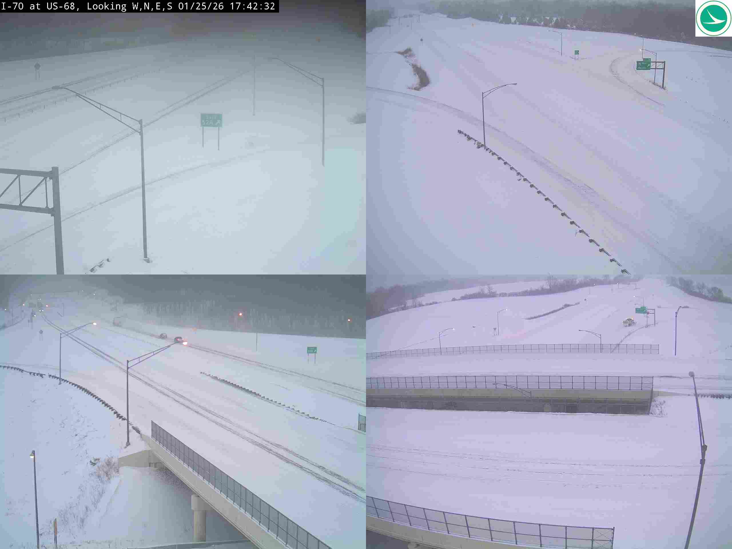
I-70 at US-68
Here's a concise analysis of the traffic camera image:
Road Conditions: Heavily snow-covered. Roads appear slick and visibility is significantly reduced.
Traffic Flow: Light to moderate traffic in both directions. Vehicles are spaced apart, likely due to weather conditions.
Weather Visibility: Very poor due to heavy snowfall. Whiteout conditions are likely in some areas.
Incidents/Observations: No visible incidents in the image. However, the conditions suggest travel is hazardous. Snow accumulation on guardrails indicates recent snowfall.
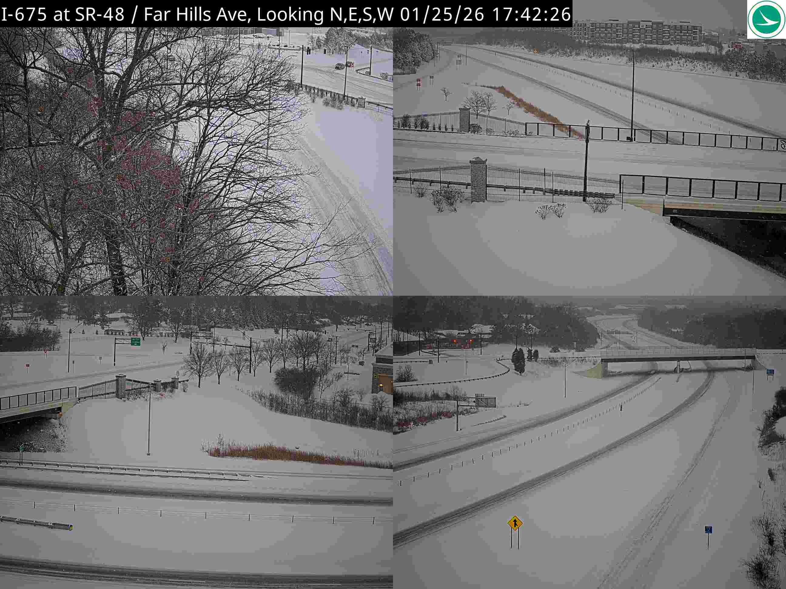
I-675 at SR-48/Far Hills Ave
Here's a concise analysis of the traffic camera image:
Road Conditions: Heavily snow-covered. Lanes are visible but appear slick.
Traffic Flow: Light to moderate, vehicles spaced apart. Traffic appears slowed due to snow.
Weather Visibility: Reduced due to snowfall. Visibility appears moderate but impacted by falling snow.
Incidents/Observations: No visible incidents. Overhead signage illuminated. Overall conditions suggest hazardous driving.
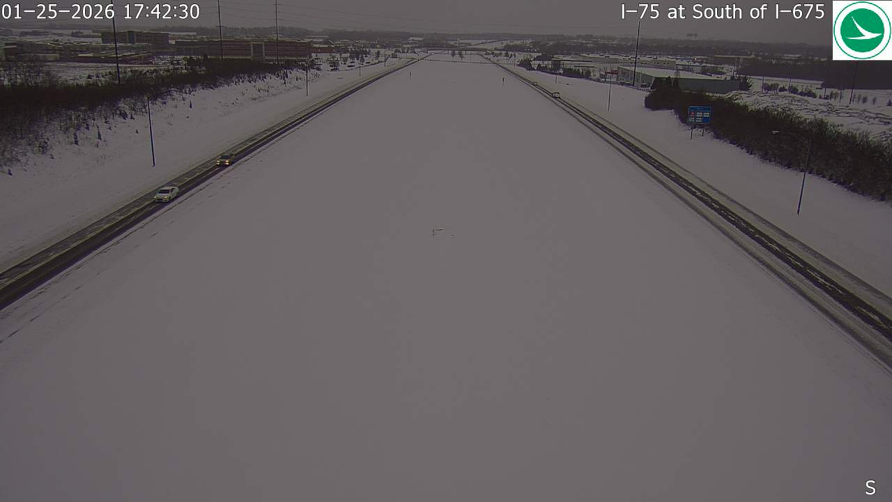
I-75 at South of I-675
Here's a concise analysis of the traffic camera image:
Road Conditions: Heavily snow-covered; visibility significantly reduced. Lanes are barely distinguishable.
Traffic Flow: Light to moderate, but slowed due to snow. Vehicles appear spaced apart.
Weather Visibility: Very poor due to heavy snowfall. Whiteout conditions likely.
Incidents/Observations: No visible incidents in the immediate view. Conditions suggest travel is hazardous.
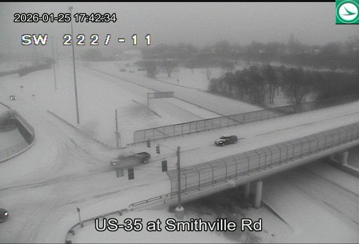
US-35 at Smithville Rd
Here's a concise analysis of the traffic camera image:
Road Conditions: Heavily snow-covered. Visibility appears significantly reduced due to falling/accumulating snow.
Traffic Flow: Light to moderate traffic flow in both directions. Vehicles appear spaced apart.
Weather Visibility: Very poor - heavy snowfall obscuring distant objects. Gray/whiteout conditions.
Incidents/Observations: No immediately visible incidents. A couple of vehicles are visible on the bridge. The SW wind speed is indicated as 22 mph with gusts up to -11 (likely a negative sign error in display).
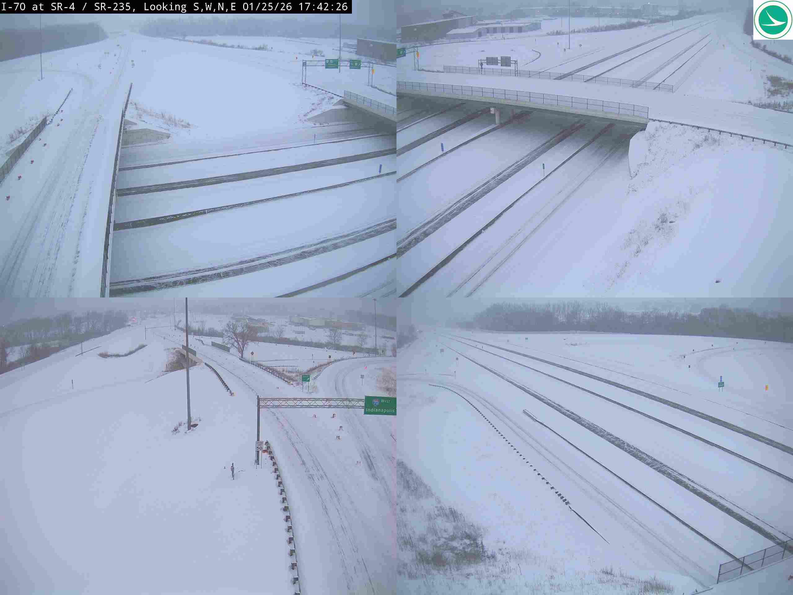
I-70 at SR-4 / SR-235
Here's a concise analysis of the traffic camera image:
Road Conditions: Heavily snow-covered. Lanes appear slick and visibility is reduced due to falling snow.
Traffic Flow: Moderate but slowed due to weather. Cars are spaced apart, indicating cautious driving.
Weather Visibility: Poor - significant snowfall obscuring distant objects. Whiteout conditions likely in some areas.
Incidents/Observations: No visible crashes or disabled vehicles in the immediate view. A lone figure appears walking along the shoulder in the lower left corner, potentially stranded or assisting others. Overall, conditions suggest travel is hazardous.
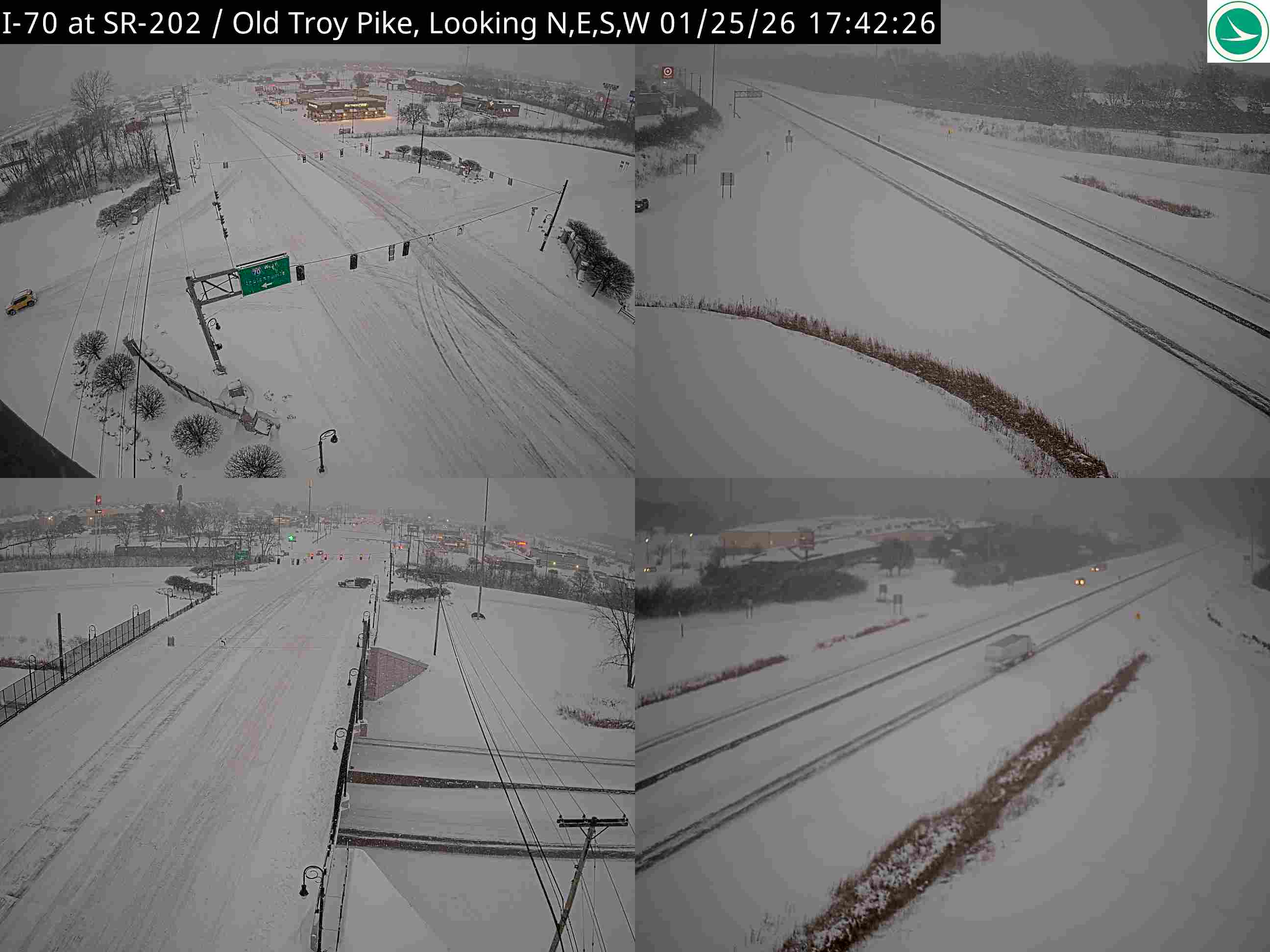
I-70 at SR-202 / Old Troy Pike
Here's a concise analysis of the traffic camera image:
Road Conditions: Heavily snow-covered. Lanes are visible but obscured by snow accumulation.
Traffic Flow: Moderate but slowed due to weather. Visible vehicles are spaced apart.
Weather Visibility: Poor - significant snowfall reducing visibility. Whiteout conditions likely in some areas.
Incidents/Observations: No visible crashes or disabled vehicles in the frame. Overhead lights are illuminated due to low visibility. Traffic signals are visible in the foreground.
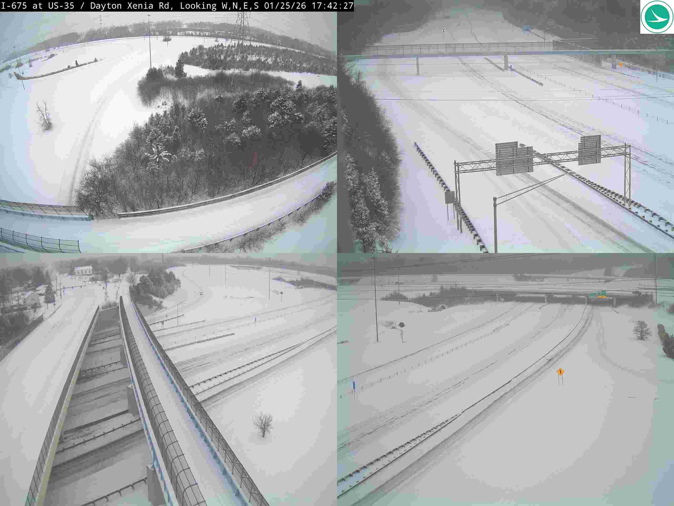
I-675 at US-35 / Dayton Xenia Rd
Here's a concise analysis of the traffic camera image:
Road Conditions: Heavily snow-covered. Lanes are barely visible in some areas. Accumulation appears substantial.
Traffic Flow: Light to moderate, but spaced out due to conditions. Traffic appears slowed in all directions.
Weather Visibility: Poor - significantly reduced due to snowfall. Visibility is likely under a mile.
Incidents/Observations: No visible incidents in the image. However, conditions suggest travel is hazardous. A lone vehicle appears stopped in one lane in the lower right quadrant.
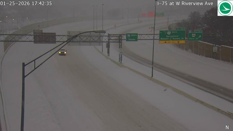
I-75 at W Riverview Ave
Here's a concise analysis of the traffic camera image:
Road Conditions: Snow-covered; appears icy/slushy.
Traffic Flow: Light to moderate, but spaced out due to conditions.
Weather Visibility: Poor - heavy snowfall significantly reduces visibility.
Incidents/Observations: A vehicle appears stopped in the right lane ahead. Possible minor incident or simply slowed due to conditions. Overhead signs are visible but partially obscured by snow.
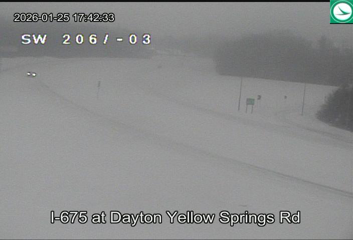
I-675 at Dayton Yellow Springs Rd
Here's a concise analysis of the traffic camera image:
Road Conditions: Heavily snow-covered. Visibility is significantly reduced.
Traffic Flow: Very light; only a few vehicles visible in the distance. Traffic appears slow or stopped.
Weather Visibility: Extremely poor due to heavy snowfall. Whiteout conditions are likely.
Incidents/Observations: No visible incidents in the immediate view. However, the conditions suggest travel is hazardous.
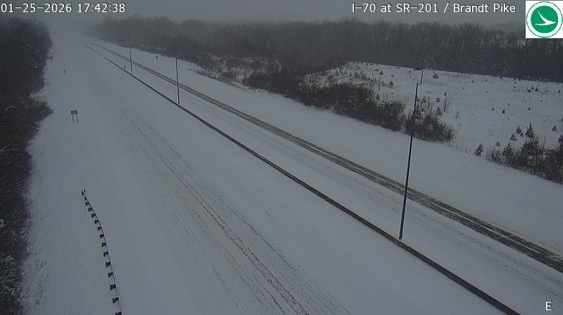
I-70 at SR-201 / Brandt Pike
Here's a concise analysis of the traffic camera image:
Road Conditions: Heavily snow-covered. Lanes appear partially cleared but still covered in snow/slush.
Traffic Flow: Light to moderate traffic in both directions. Vehicles are spaced apart.
Weather Visibility: Very poor due to falling snow. Visibility is significantly reduced.
Incidents/Observations: No visible incidents in the image. Conditions suggest travel could be hazardous.
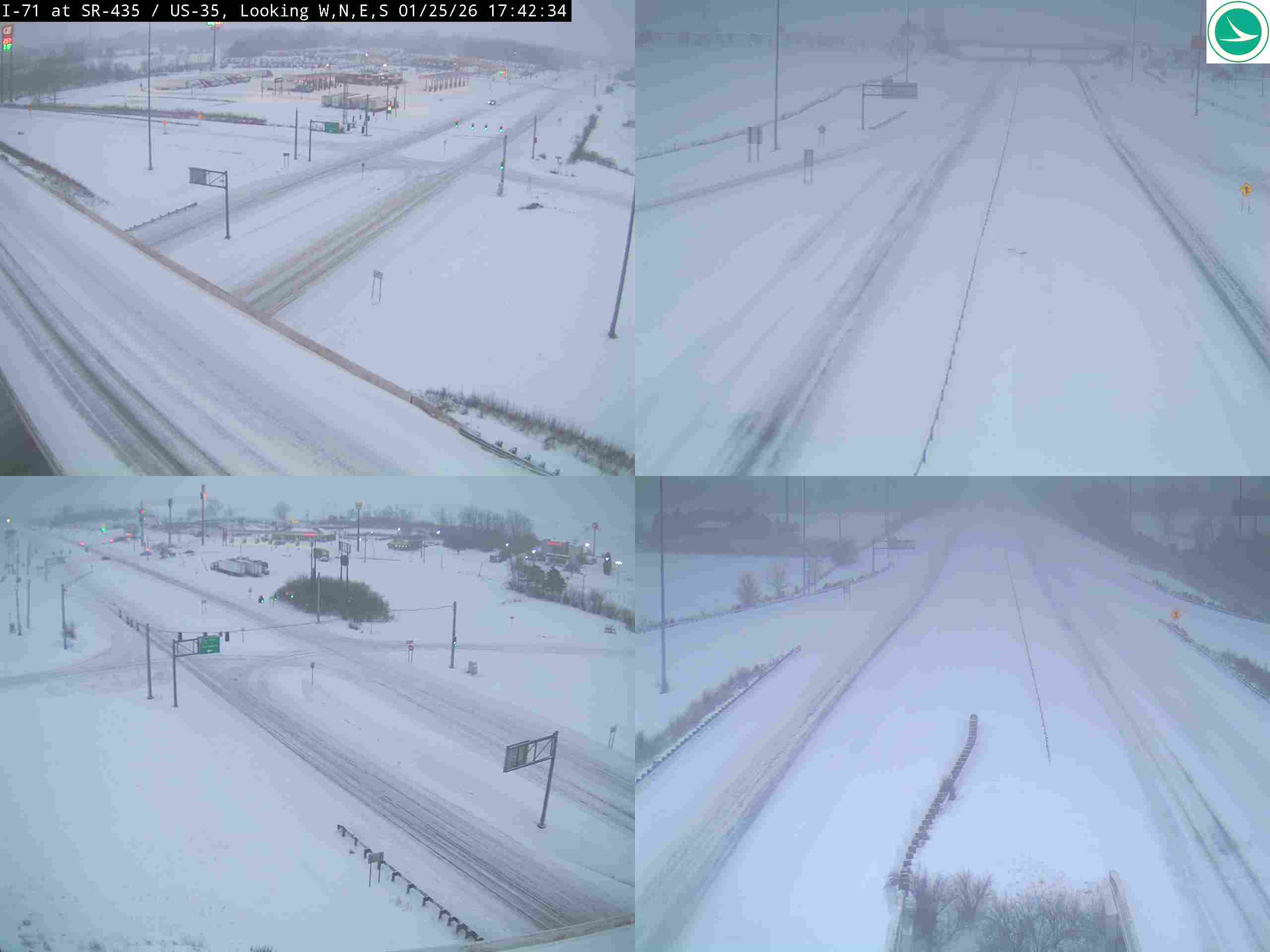
I-71 at SR-435/US-35
Here's a concise analysis of the traffic camera image:
Road Conditions: Heavily snow-covered; lanes are visible but obscured by snow accumulation. Likely icy/slippery conditions.
Traffic Flow: Moderate to light traffic in all lanes. Vehicles appear spaced apart.
Weather Visibility: Poor visibility due to falling/accumulated snow. Whiteout conditions possible.
Incidents/Observations: No visible incidents in the image. Overhead signs are partially obscured by snow. Overall conditions suggest travel is hazardous.
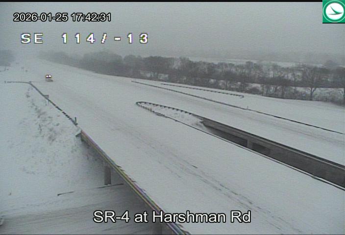
SR-4 at Harshman Rd
Here's an analysis of the traffic camera image:
Road Conditions: Heavily snow-covered. Lanes are barely visible.
Traffic Flow: Light to moderate, vehicles spaced apart.
Weather Visibility: Very poor due to snowfall. Whiteout conditions likely.
Incidents/Observations: No visible incidents in the immediate view. However, the road conditions suggest travel is hazardous. A possible vehicle is visible in the distance.
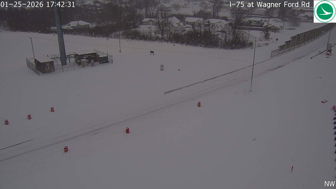
I-75 at Wagner Ford Rd
Here's a concise analysis of the traffic camera image:
Road Conditions: Heavily snow-covered. Roads appear slick and visibility is significantly reduced.
Traffic Flow: Light to moderate traffic in both directions. Vehicles are spaced apart.
Weather Visibility: Very poor due to falling snow. A whiteout condition seems likely.
Incidents/Observations: A possible stalled vehicle or debris is visible in the left lane near the center of the image. Red flares have been deployed nearby. NW wind direction indicated.
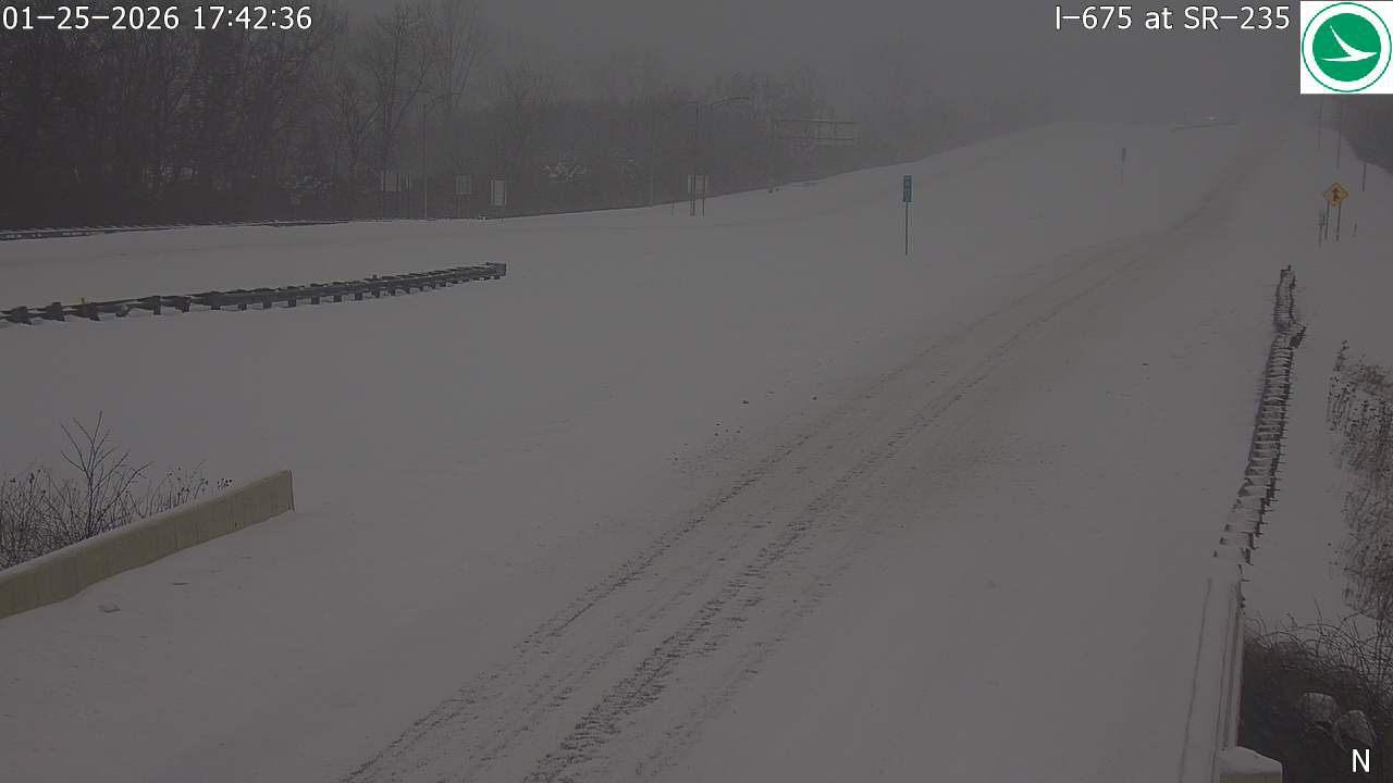
I-675 at SR-235
Here's a concise analysis of the traffic camera image:
Road Conditions: Heavily snow-covered. Road surface appears completely white, indicating significant accumulation. Tire tracks are visible, suggesting some traffic has passed through.
Traffic Flow: Light to moderate traffic flow in both directions. Vehicles are spaced apart.
Weather Visibility: Very poor visibility due to heavy snowfall. It's difficult to discern details beyond immediate proximity. A grey/white haze dominates the image.
Incidents/Observations: No visible incidents (accidents or disabled vehicles) in the immediate view. Conditions suggest travel will be hazardous.
Auto-refresh active